IMAGES TAKEN NEAR TO
Brockley Combe Road, BRISTOL, BS48 3DG
Introduction
This page details the photographs taken nearby to Brockley Combe Road, BS48 3DG by members of the Geograph project.
The Geograph project started in 2005 with the aim of publishing, organising and preserving representative images for every square kilometre of Great Britain, Ireland and the Isle of Man.

There are currently over 7.5m images from over14,400 individuals and you can help contribute to the project by visiting https://www.geograph.org.uk
Image Map
Images are licensed for reuse under creativecommons.org/licenses/by-sa/2.0
Notes
- Clicking on the map will re-center to the selected point.
- The higher the marker number, the further away the image location is from the centre of the postcode.
Image Listing (10 Images Found)
Images are licensed for reuse under creativecommons.org/licenses/by-sa/2.0
Image
Details
Distance
1
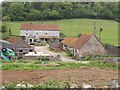
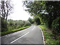
Coombehead Farm
Five years on from Image, taken from the same spot by Brockley Combe Road. Not exactly at the head of Brockley Combe, but the valley certainly deepens below here and becomes wooded. The wood in the background is Healls Scars.
Image: © Derek Harper
Taken: 16 May 2011
0.01 miles
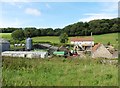
6
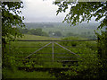
A gate above Coombehead Farm
The mist has landed at Bristol Airport in the distance; the farm and Downside village lie before in the valley.
Image: © Neil Owen
Taken: 31 May 2018
0.18 miles
8
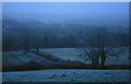
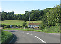
Looking south from Backwell Hill
Taken in the gloaming on New Year's Eve 2008. In better visibility the Mendips loom in the distance. The hoar frost persisted all day (and throughout the next day too).
Image: © Hugh Chevallier
Taken: Unknown
0.19 miles
9
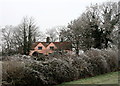
Magpie Hill, Long Lane, Backwell Hill
This pink house, known as Magpie Hill, overlooks Bristol Airport from the flank of Backwell Hill. It was built in the 1920s as a pair of cottages, but was converted into a single dwelling in the 1950s or 1960s. This photograph was taken on New Year's Day, 2009, when the hoar frost never melted.
Image: © Hugh Chevallier
Taken: 1 Jan 2009
0.23 miles
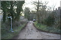
10
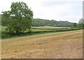
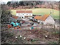
Brockley Combe
The upper part of the combe seen from near Coombehead Farm, with Healls Scars the wood on the north side of the valley.
Image: © Derek Harper
Taken: 16 May 2011
0.23 miles