IMAGES TAKEN NEAR TO
Brockley Combe Road, BRISTOL, BS48 3DF
Introduction
This page details the photographs taken nearby to Brockley Combe Road, BS48 3DF by members of the Geograph project.
The Geograph project started in 2005 with the aim of publishing, organising and preserving representative images for every square kilometre of Great Britain, Ireland and the Isle of Man.

There are currently over 7.5m images from over14,400 individuals and you can help contribute to the project by visiting https://www.geograph.org.uk
Image Map (Loading...)


Getting Data...Please wait
Leaflet Map data © OpenStreetMap
Images are licensed for reuse under creativecommons.org/licenses/by-sa/2.0
Notes
- Clicking on the map will re-center to the selected point.
- The higher the marker number, the further away the image location is from the centre of the postcode.
Image Listing (6 Images Found)
Images are licensed for reuse under creativecommons.org/licenses/by-sa/2.0
Image
Details
Distance
2
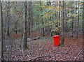
For leaf litter
An un-missable and incongruous red waste bin in the forest; the nearby paintball zone may have something to do with it.
Image: © Neil Owen
Taken: 2 Nov 2016
0.22 miles
3
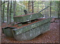
Enemy tank in the combe
Don't worry - it's not a real one, just a paintball prop. It seems to have had plenty of action, nonetheless.
Image: © Neil Owen
Taken: 2 Nov 2016
0.24 miles
4
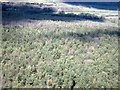
Warren Plantation from the air
Seen on approach to Bristol Airport.
Image: © Thomas Nugent
Taken: 7 Apr 2023
0.25 miles
5
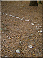
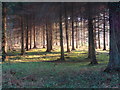
A conference of fairies?
Some well-defined fungal ringwork in what is primarily a beech plantation.
Image: © Neil Owen
Taken: 2 Nov 2016
0.25 miles
6

Brockley : Aerial Scenery
Looking across the woodland and beyond.
Image: © Lewis Clarke
Taken: 8 Jun 2022
0.25 miles