IMAGES TAKEN NEAR TO
Long Lane, BRISTOL, BS48 3BY
Introduction
This page details the photographs taken nearby to Long Lane, BS48 3BY by members of the Geograph project.
The Geograph project started in 2005 with the aim of publishing, organising and preserving representative images for every square kilometre of Great Britain, Ireland and the Isle of Man.

There are currently over 7.5m images from over14,400 individuals and you can help contribute to the project by visiting https://www.geograph.org.uk
Image Map
Images are licensed for reuse under creativecommons.org/licenses/by-sa/2.0
Notes
- Clicking on the map will re-center to the selected point.
- The higher the marker number, the further away the image location is from the centre of the postcode.
Image Listing (17 Images Found)
Images are licensed for reuse under creativecommons.org/licenses/by-sa/2.0
Image
Details
Distance
1
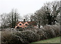
Magpie Hill, Long Lane, Backwell Hill
This pink house, known as Magpie Hill, overlooks Bristol Airport from the flank of Backwell Hill. It was built in the 1920s as a pair of cottages, but was converted into a single dwelling in the 1950s or 1960s. This photograph was taken on New Year's Day, 2009, when the hoar frost never melted.
Image: © Hugh Chevallier
Taken: 1 Jan 2009
0.01 miles
2
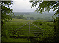
A gate above Coombehead Farm
The mist has landed at Bristol Airport in the distance; the farm and Downside village lie before in the valley.
Image: © Neil Owen
Taken: 31 May 2018
0.04 miles
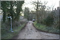
4
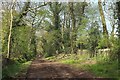
Junction on Backwell Hill
On the right is the start of the no through road past Home Farm to long Lane and the outside world. Behind the camera is the start, or end in my case, of the byway shown in Image], and a footpath down to Backwell West Town.
Image: © Derek Harper
Taken: 3 May 2016
0.16 miles
5
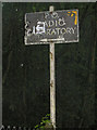
A sign from the war?
This odd sign refers to the old Post Office radio laboratory that was established here in 1937. The P.O. research at Dollis Hill in London moved here shortly before WWII began, presumably due to the threat. At Backwell, work on disrupting Luftwaffe bombing aids was undertaken, along with V.H.F. television broadcasting. After the war, the site was redirected into new radio transmissions and cloud interaction research. Later still, the modern digital age was advanced by the new 'owners' British Telecom. The site closed around 1975 (apart from some other occasional B.T. research in the 1980s) and the various buildings are rapidly deteriorating.
Apparently, the site was sold to a B.T. manager in 1993; following his later death, the site is now being earmarked for housing developments, most of which have so far been rejected.
Image: © Neil Owen
Taken: 31 May 2018
0.16 miles
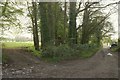
6
Byway on Backwell Hill
Approaching the end of a long straight stretch of restricted byway LA2 18/40 near Backwell Hill House.
Image: © Derek Harper
Taken: 3 May 2016
0.17 miles
7
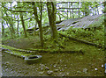
Collapsing under the galvanised sheeting
This old and neglected building is near the site of the old Post Office radio research laboratories. It carried out important (but perhaps not exactly top secret) work during WWII, then spend many years investigating various radio technology and environmental factors before closing in the 1970s. It looks like the buildings were built quickly and abandoned with equal haste.
Image: © Neil Owen
Taken: 31 May 2018
0.18 miles
8
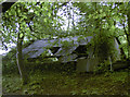
Farm building or laboratory
This galvanised building might well be a simple farm structure, but down the hill the nearby site used to be a radio technology research centre during WWII. The internal bracing is common with buildings of that date.
Image: © Neil Owen
Taken: 31 May 2018
0.19 miles
9
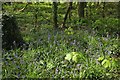
Bluebells, Backwell Hill
In a narrow belt of woodland beside restricted byway LA2 18/40.
Image: © Derek Harper
Taken: 3 May 2016
0.19 miles
10
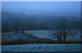
Looking south from Backwell Hill
Taken in the gloaming on New Year's Eve 2008. In better visibility the Mendips loom in the distance. The hoar frost persisted all day (and throughout the next day too).
Image: © Hugh Chevallier
Taken: Unknown
0.19 miles