IMAGES TAKEN NEAR TO
Chelvey Batch, BRISTOL, BS48 3AR
Introduction
This page details the photographs taken nearby to Chelvey Batch, BS48 3AR by members of the Geograph project.
The Geograph project started in 2005 with the aim of publishing, organising and preserving representative images for every square kilometre of Great Britain, Ireland and the Isle of Man.

There are currently over 7.5m images from over14,400 individuals and you can help contribute to the project by visiting https://www.geograph.org.uk
Image Map
Images are licensed for reuse under creativecommons.org/licenses/by-sa/2.0
Notes
- Clicking on the map will re-center to the selected point.
- The higher the marker number, the further away the image location is from the centre of the postcode.
Image Listing (8 Images Found)
Images are licensed for reuse under creativecommons.org/licenses/by-sa/2.0
Image
Details
Distance
1
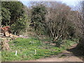
Entrance to Tap's Combe
The track leading to the Combe is in a sheltered spot, brightened with Spring flowers and a topped tree.
Image: © Neil Owen
Taken: 24 Mar 2022
0.11 miles
2
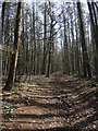
Trees along Tap's Combe
The track wends through some gently sloping land, well covered by trees.
Image: © Neil Owen
Taken: 24 Mar 2022
0.14 miles
3
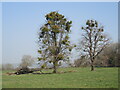
Mistletoe in trees near Brockley
A pair of surviving trees have a mantle of mistletoe.
Image: © Neil Owen
Taken: 24 Mar 2022
0.19 miles
4
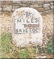
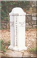
Old Milestone, A370, Chelvey Batch, Brockley
The milestone is located on the grass and gravel verge adjacent to the boundary marker SO_BRWSpb Image, on the south east side of the road. Parish of Brockley (North Somerset District). Metal plate attached to stone post, Bristol iron plate design, erected by the Bristol turnpike trust in the 19th century.
Inscription reads:-
8
MILES
TO
BRISTOL
Carved benchmark and rivet on top.
Grade II listed, List Entry Number: 1320639 https://historicengland.org.uk/listing/the-list/list-entry/1320639
Milestone Society National ID: SO_BRWS08
Image: © Janet Dowding
Taken: 26 Sep 2002
0.20 miles
5
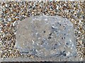
Ordnance Survey Rivet
This OS rivet can be found on the milestone SE side of the road. It marks a point 39.981m above mean sea level.
Image: © Adrian Dust
Taken: 4 Aug 2022
0.20 miles
6
Old Boundary Marker
Parish Boundary Marker - Turnpike by the A370, in parish of Brockley (North Somerset District), on the southwest side of the A370 at Chelvey Batch next to milestone SO_BRWS08.
surveyed
Milestone Society National ID: SO_BRWSpb
Image: © Milestone Society
Taken: Unknown
0.21 miles
7
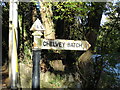
Direction Sign ? Signpost on the A370 at Chelvey Batch
Located on the northeast side of the junction of the A370 Main Road and Chelvey Batch in Brockley parish. 1 arm and pyramid finial.
Milestone Society National ID: SO_ST4766
Image: © Roadside Relics
Taken: 2 Nov 2021
0.23 miles
8
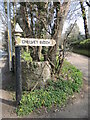
Signpost to Chelvey Batch
Just off the A370, and in typical Somerset style.
Image: © Neil Owen
Taken: 24 Mar 2022
0.24 miles