IMAGES TAKEN NEAR TO
Goss Barton, BRISTOL, BS48 2XD
Introduction
This page details the photographs taken nearby to Goss Barton, BS48 2XD by members of the Geograph project.
The Geograph project started in 2005 with the aim of publishing, organising and preserving representative images for every square kilometre of Great Britain, Ireland and the Isle of Man.

There are currently over 7.5m images from over14,400 individuals and you can help contribute to the project by visiting https://www.geograph.org.uk
Image Map (Loading...)


Getting Data...Please wait
Leaflet Map data © OpenStreetMap
Images are licensed for reuse under creativecommons.org/licenses/by-sa/2.0
Notes
- Clicking on the map will re-center to the selected point.
- The higher the marker number, the further away the image location is from the centre of the postcode.
Image Listing (27 Images Found)
Images are licensed for reuse under creativecommons.org/licenses/by-sa/2.0
Image
Details
Distance
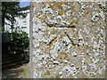
1
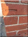
Ordnance Survey Cut Mark
This OS Cut Mark can be found on the NE face of No60 Whitefield Road. It marks a point 24.6583m above mean sea level.
Image: © Adrian Dust
Taken: 18 Jul 2013
0.06 miles
2
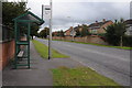
Bus stop on Queens Road
Bus stop on Queens Road in Nailsea.
Image: © Philip Halling
Taken: 10 Sep 2011
0.12 miles
3
Ordnance Survey Cut Mark
This OS Cut Mark can be found on the front of No19 Union Street. It marks a point 21.9243m above mean sea level.
Image: © Adrian Dust
Taken: 18 Jul 2013
0.17 miles
5
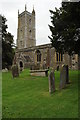
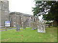
Nailsea church
Nailsea church is dedicated Holy Trinity.
Image: © Philip Halling
Taken: 10 Sep 2011
0.18 miles
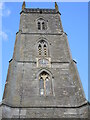
6
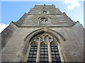
The west face of the west tower
Holy Trinity viewed from ground level: to quote Historic England it has a '3-light window above with hood mould and mask stops, 2nd stage has similar smaller 2-light window all sides, 3rd stage has 2-light bell-openings with stone tracery and hood mould, similar openings at 4th stage'.
Image: © Neil Owen
Taken: 29 Sep 2021
0.18 miles
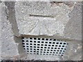
7
Ordnance Survey Cut Mark
This OS cut mark can be found a buttress of Holy Trinity Church. It marks a point 34.196m above mean sea level.
Image: © Adrian Dust
Taken: 28 Jun 2014
0.18 miles
8
South face of the west tower
The tower features a clock, but only on the south side. Grade I listed.
Image: © Neil Owen
Taken: 29 Sep 2021
0.18 miles
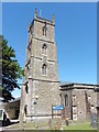
9
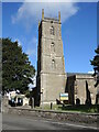
Trinity's tower
Holy Trinity dates from the fifteenth century, with a fine four stage tower in Perpendicular style - typical of the area. Interestingly, the pinnacles were not added until 1904 and the belfrey contains a bell that was originally in Bristol Gaol.
Image: © Neil Owen
Taken: 29 Sep 2021
0.18 miles