IMAGES TAKEN NEAR TO
Tetbury Gardens, BRISTOL, BS48 2TJ
Introduction
This page details the photographs taken nearby to Tetbury Gardens, BS48 2TJ by members of the Geograph project.
The Geograph project started in 2005 with the aim of publishing, organising and preserving representative images for every square kilometre of Great Britain, Ireland and the Isle of Man.

There are currently over 7.5m images from over14,400 individuals and you can help contribute to the project by visiting https://www.geograph.org.uk
Image Map
Images are licensed for reuse under creativecommons.org/licenses/by-sa/2.0
Notes
- Clicking on the map will re-center to the selected point.
- The higher the marker number, the further away the image location is from the centre of the postcode.
Image Listing (7 Images Found)
Images are licensed for reuse under creativecommons.org/licenses/by-sa/2.0
Image
Details
Distance
1
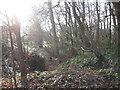
Woodland on the edge of a former sandstone quarry
The local red pennant sandstone was used for roofing.
Image: © Dr Duncan Pepper
Taken: 13 Jan 2012
0.06 miles
2
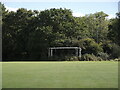
Goals in hibernation
Some woodwork left at the edge of the playing fields, waiting for the new season to kick off.
Image: © Neil Owen
Taken: 29 Sep 2021
0.14 miles
4
St Francis' Catholic Primary School, Nailsea
Viewed from Station Road.
Image: © Jaggery
Taken: 13 Jul 2012
0.17 miles
5
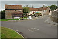
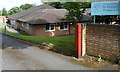
The Old Farmhouse
The Old Farmhouse public house in Nailsea.
Image: © Philip Halling
Taken: 10 Sep 2011
0.19 miles
6
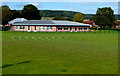
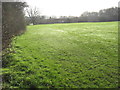
School playing fields, Nailsea
On the south side of Golden Valley Primary School.
Image: © Jaggery
Taken: 13 Jul 2012
0.23 miles
7
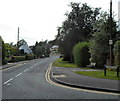
Ash Hayes Road, Nailsea
Viewed across Station Road.
Image: © Jaggery
Taken: 13 Jul 2012
0.24 miles