IMAGES TAKEN NEAR TO
Abbotsbury Road, BRISTOL, BS48 2QL
Introduction
This page details the photographs taken nearby to Abbotsbury Road, BS48 2QL by members of the Geograph project.
The Geograph project started in 2005 with the aim of publishing, organising and preserving representative images for every square kilometre of Great Britain, Ireland and the Isle of Man.

There are currently over 7.5m images from over14,400 individuals and you can help contribute to the project by visiting https://www.geograph.org.uk
Image Map
Images are licensed for reuse under creativecommons.org/licenses/by-sa/2.0
Notes
- Clicking on the map will re-center to the selected point.
- The higher the marker number, the further away the image location is from the centre of the postcode.
Image Listing (35 Images Found)
Images are licensed for reuse under creativecommons.org/licenses/by-sa/2.0
Image
Details
Distance
1
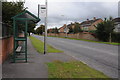
Bus stop on Queens Road
Bus stop on Queens Road in Nailsea.
Image: © Philip Halling
Taken: 10 Sep 2011
0.10 miles
2
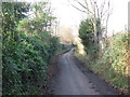
Haslands (Lane)
Formerly the main East West road through Nailsea before modern developments.
Image: © Dr Duncan Pepper
Taken: 13 Jan 2012
0.11 miles
4
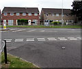
Queens Road houses, Nailsea
Opposite Mizzymead Road.
Image: © Jaggery
Taken: 8 Jun 2016
0.16 miles
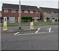
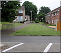
5
Mizzymead Road gas installation, Nailsea
The Wales & West Utilities gas installation is near the 30 sign, viewed from the corner of Queens Road.
Image: © Jaggery
Taken: 8 Jun 2016
0.17 miles
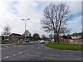
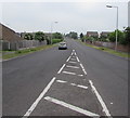
6
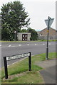
Queens Road pedestrian refuge and road direction signs, Nailsea
Near the Mizzymead Road junction.
Image: © Jaggery
Taken: 8 Jun 2016
0.17 miles
7
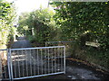
West entrance to Beckett's Lane
Off The Perrings, the footpath was once the road to the Pink Cottage of old.
Image: © Neil Owen
Taken: 29 Sep 2021
0.18 miles
8
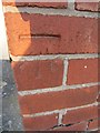
Ordnance Survey Cut Mark
This OS Cut Mark can be found on the NE face of No60 Whitefield Road. It marks a point 24.6583m above mean sea level.
Image: © Adrian Dust
Taken: 18 Jul 2013
0.18 miles
9
Mizzymead Road, Nailsea
From Queens Road along Mizzymead Road towards the town centre.
Image: © Jaggery
Taken: 8 Jun 2016
0.18 miles
10
Footpath on the southwest side of Queens Road Nailsea
Towards Church Hayes Drive and Church Hayes Close.
Image: © Jaggery
Taken: 8 Jun 2016
0.20 miles