IMAGES TAKEN NEAR TO
Hillcrest Close, BRISTOL, BS48 2HP
Introduction
This page details the photographs taken nearby to Hillcrest Close, BS48 2HP by members of the Geograph project.
The Geograph project started in 2005 with the aim of publishing, organising and preserving representative images for every square kilometre of Great Britain, Ireland and the Isle of Man.

There are currently over 7.5m images from over14,400 individuals and you can help contribute to the project by visiting https://www.geograph.org.uk
Image Map
Images are licensed for reuse under creativecommons.org/licenses/by-sa/2.0
Notes
- Clicking on the map will re-center to the selected point.
- The higher the marker number, the further away the image location is from the centre of the postcode.
Image Listing (106 Images Found)
Images are licensed for reuse under creativecommons.org/licenses/by-sa/2.0
Image
Details
Distance
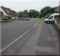
1
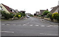
Hillcrest Road, Nailsea
On the west side of Mizzymead Road.
Image: © Jaggery
Taken: 8 Jun 2016
0.03 miles
2
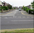
West along Hillcrest Road, Nailsea
From Mizzymead Road.
Image: © Jaggery
Taken: 8 Jun 2016
0.05 miles
3
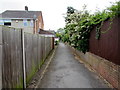
Footpath between fences, Nailsea
From the west side of Mizzymead Road, the path leads to Dunkery Close and Coombe Road.
Image: © Jaggery
Taken: 8 Jun 2016
0.06 miles
4
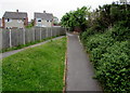
Path junction near Mizzymead Road, Nailsea
On the west side of Mizzymead Road, the path on the left joins a path ascending from a Mizzymead Road underpass.
Image: © Jaggery
Taken: 8 Jun 2016
0.07 miles
5
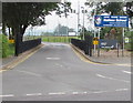
Mizzymead Road toward Nailsea town centre
Mizzymead Road is here between the two junctions with Hillcrest Road which
follows a roughly rectangular course beyond the left (west) side of the photo.
Image: © Jaggery
Taken: 8 Jun 2016
0.07 miles
6
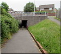
Underpass below Mizzymead Road, Nailsea
A footpath from Coombe Road descends towards the Mizzymead Road underpass.
Image: © Jaggery
Taken: 8 Jun 2016
0.08 miles
8
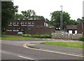
Nailsea Police Station
Part of Avon and Somerset Constabulary, viewed across Stock Way South.
Image: © Jaggery
Taken: 8 Jun 2016
0.10 miles
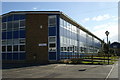
9
Entrance to Nailsea School, Nailsea
From Mizzymead Road. Nailsea School is a secondary school and Sixth Form.
The School converted to an Academy on September 1st 2012.
Image: © Jaggery
Taken: 8 Jun 2016
0.10 miles
10
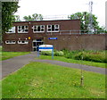
Nailsea Police Station
Part of Avon and Somerset Constabulary, viewed from Stock Way South.
Image: © Jaggery
Taken: 8 Jun 2016
0.11 miles