IMAGES TAKEN NEAR TO
Nightingale Gardens, BRISTOL, BS48 2BQ
Introduction
This page details the photographs taken nearby to Nightingale Gardens, BS48 2BQ by members of the Geograph project.
The Geograph project started in 2005 with the aim of publishing, organising and preserving representative images for every square kilometre of Great Britain, Ireland and the Isle of Man.

There are currently over 7.5m images from over14,400 individuals and you can help contribute to the project by visiting https://www.geograph.org.uk
Image Map (Loading...)


Getting Data...Please wait
Leaflet Map data © OpenStreetMap
Images are licensed for reuse under creativecommons.org/licenses/by-sa/2.0
Notes
- Clicking on the map will re-center to the selected point.
- The higher the marker number, the further away the image location is from the centre of the postcode.
Image Listing (15 Images Found)
Images are licensed for reuse under creativecommons.org/licenses/by-sa/2.0
Image
Details
Distance
1
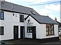
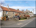
Noggin's Old Fish Bar
It's the bar that is old, not the fish. The old kebab shop appears to have gone.
Image: © Neil Owen
Taken: 29 Sep 2021
0.14 miles
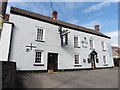
2
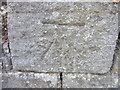
Ordnance Survey Cut Mark
This OS Cut Mark can be found on a roadside wall in front of Moorfield House, Silver Street. It marks a point 22.9392m above mean sea level.
Image: © Adrian Dust
Taken: 18 Jul 2013
0.14 miles
4
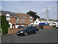
Causeway View
2000s houses with photo-voltaic cells and a Ford Mondeo Mk3 in Nailsea.
Image: © Burgess Von Thunen
Taken: 29 Feb 2012
0.20 miles
6
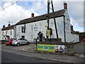
The White Lion, Nailsea
A traditional pub on the west end of Nailsea.
Image: © Neil Owen
Taken: 29 Sep 2021
0.21 miles
7
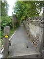
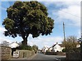
Start of Loop Walk
This walkway on Silver St, Nailsea is marked as Loop Walk.
Image: © Steve Barnes
Taken: 12 Aug 2010
0.21 miles
9
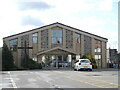
Nailsea Methodist Church
Nailsea primarily began life as a mining town in the eighteenth century and unsurprisingly has a long history of worship. Methodism was a strong component of the population and a chapel was built in 1792 on another site. This grew and a new chapel was built here in 1914, which proved popular.
However, with the rapid expansion of the town post-war it was felt that the community was in need of more facilities. MYCON (Methodist Youth Club of Nailsea) was built principally as a youth centre in 1965, which also proved well used.
But even that appeared insufficient. In 1994 a totally new building that we see today was founded which combined roles as a church and community centre.
Image: © Neil Owen
Taken: 29 Sep 2021
0.23 miles
10
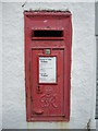
George VI box on Silver Street
An old postbox in the wall of the former Kingshill Stores and off license near Nailsea. See Image] for a wider view.
Image: © Neil Owen
Taken: 29 Sep 2021
0.23 miles