IMAGES TAKEN NEAR TO
Head Croft, BRISTOL, BS48 1US
Introduction
This page details the photographs taken nearby to Head Croft, BS48 1US by members of the Geograph project.
The Geograph project started in 2005 with the aim of publishing, organising and preserving representative images for every square kilometre of Great Britain, Ireland and the Isle of Man.

There are currently over 7.5m images from over14,400 individuals and you can help contribute to the project by visiting https://www.geograph.org.uk
Image Map (Loading...)


Getting Data...Please wait
Leaflet Map data © OpenStreetMap
Images are licensed for reuse under creativecommons.org/licenses/by-sa/2.0
Notes
- Clicking on the map will re-center to the selected point.
- The higher the marker number, the further away the image location is from the centre of the postcode.
Image Listing (37 Images Found)
Images are licensed for reuse under creativecommons.org/licenses/by-sa/2.0
Image
Details
Distance
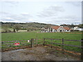
1
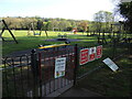
Play in Farleigh Green
A well-stocked play area at the edge of the recreation ground.
Image: © Neil Owen
Taken: 1 May 2023
0.04 miles
3
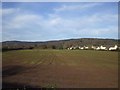
Power in Flax Bourton
The expansion of the village has required an electricity station to keep the lights on.
Image: © Neil Owen
Taken: 1 May 2023
0.07 miles
4

Union footbridge
Crossing the mainline railway it was the access to the old Bourton Station - a platform that was opened in 1860 on the old Bristol and Exeter Railway and closed in 1964. It was the first station before a second was opened a short distance west, known as Flax Bourton station.
Further on beyond the bridge was the old Long Ashton Workhouse.
Image: © Neil Owen
Taken: 10 Apr 2022
0.09 miles
5
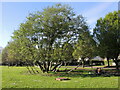
A green crown on Farleigh Green
An open space with a pavilion features a rather splendid tree that has formed a crown-like appearance. It lies on the site of the west wing of the former Bedminster Union Workhouse of the nineteenth century. Most of that institution was still used as a hospital for many years before being converted into residential use.
Image: © Neil Owen
Taken: 1 May 2023
0.10 miles
7

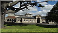
St George's church
This church was built in 1860 as part of the adjoining poorhouse. John Norton produced the design with William Gibbs (of the nearby Tyntesfield estate) providing the funding.
The inmates would have worshipped here but now the church is no longer in use. It's now on the open market as a remarkable office property with an asking price of around £625,000.
Image: © Neil Owen
Taken: 24 Mar 2014
0.12 miles
8
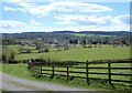
Footpath around Flax Bourton
Leaving the B3130, a footpath crosses the fields near the former Kingcot Mill.
Image: © Neil Owen
Taken: 10 Apr 2022
0.12 miles