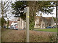
IMAGES TAKEN NEAR TO
Old Weston Road, BRISTOL, BS48 1UR
Introduction
This page details the photographs taken nearby to Old Weston Road, BS48 1UR by members of the Geograph project.
The Geograph project started in 2005 with the aim of publishing, organising and preserving representative images for every square kilometre of Great Britain, Ireland and the Isle of Man.

There are currently over 7.5m images from over14,400 individuals and you can help contribute to the project by visiting https://www.geograph.org.uk
Image Map (Loading...)


Getting Data...Please wait
Leaflet Map data © OpenStreetMap
Images are licensed for reuse under creativecommons.org/licenses/by-sa/2.0
Notes
- Clicking on the map will re-center to the selected point.
- The higher the marker number, the further away the image location is from the centre of the postcode.
Image Listing (42 Images Found)
Images are licensed for reuse under creativecommons.org/licenses/by-sa/2.0
Image
Details
Distance
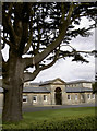
2
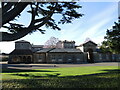
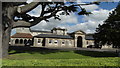
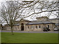
Farleigh Court
Its institutional design was a workhouse originally. Most of the buildings are still used, although not for their original purposes.
Image: © Neil Owen
Taken: 1 May 2023
0.03 miles
3
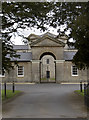
The gates to the workhouse
This was the entrance to the old Bedminster Union workhouse from 1838. Beyond it is a three-faced tower that also has a clock. It's now a small industrial estate. See Image] for more.
Image: © Neil Owen
Taken: 24 Mar 2014
0.03 miles
4
One form of work or another
This is Farleigh Court, now a commercial estate with a number of individual companies based here. However, this particular building has a different past: it was built in 1837-8 as Bedminster Union Poor House.
After the passing of the Poor Act, the commissioners raised some £6,600 to establish a significant institution to deal with the needy and destitute of south Bristol and other areas. George Gilbert Scott and William Bonython Moffatt were engaged to design the blocks (as they had with other poorhouses) to hold some 300 inmates.
In 1899 the governors renamed it as Long Ashton Union and its intake of the poor continued until 1929. It then became Cambridge House, a mental health treatment facility. In 1956 it was renamed Farleigh Hospital, but in 1971 a couple of nurses working there blew the whistle on the scandalous way some vulnerable patients were treated and it was closed.
However, in 2005 it was converted into a small industrial and commercial estate, with much of the impressive architecture being retained as a testament to those who had passed its gates.
See Image] for more views.
Image: © Neil Owen
Taken: 24 Mar 2014
0.03 miles
5
Farleigh Court
This impressive commercial estate was formerly a workhouse. See Image] for another view.
Image: © Neil Owen
Taken: 24 Mar 2014
0.03 miles
6

St George's church
This church was built in 1860 as part of the adjoining poorhouse. John Norton produced the design with William Gibbs (of the nearby Tyntesfield estate) providing the funding.
The inmates would have worshipped here but now the church is no longer in use. It's now on the open market as a remarkable office property with an asking price of around £625,000.
Image: © Neil Owen
Taken: 24 Mar 2014
0.04 miles
7
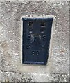
Ordnance Survey Flush Bracket (88)
This OS Flush Bracket can be found on the south angle of the Magistrates Court. It marks a point 42.019m above mean sea level.
Image: © Adrian Dust
Taken: 24 Aug 2022
0.04 miles
8
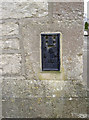
Coroner's flush bracket
Installed in the old police station in the early twentieth century, this flush bracket is numbered '88' - an early example. See http://www.bench-marks.org.uk/bm2 for the entry in the Benchmark Database and Image] for a wider view.
Image: © Neil Owen
Taken: 24 Mar 2014
0.04 miles
9
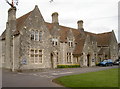
One court or another
This used to be the old police station, built in 1857-58 by John Norton, and Long Ashton Magistrate's Court. It's now home to the coroner's offices. On the nearest corner is a flush bracket - see Image
Image: © Neil Owen
Taken: 24 Mar 2014
0.05 miles
10
Past the courts
This footpath carries onto the railway bridge to the north. It runs past the old police station - which is now the coroner's court for the county. See Image] for a clearer view.
Image: © Neil Owen
Taken: 24 Mar 2014
0.05 miles