IMAGES TAKEN NEAR TO
Charlton Drive, BRISTOL, BS48 1PE
Introduction
This page details the photographs taken nearby to Charlton Drive, BS48 1PE by members of the Geograph project.
The Geograph project started in 2005 with the aim of publishing, organising and preserving representative images for every square kilometre of Great Britain, Ireland and the Isle of Man.

There are currently over 7.5m images from over14,400 individuals and you can help contribute to the project by visiting https://www.geograph.org.uk
Image Map
Images are licensed for reuse under creativecommons.org/licenses/by-sa/2.0
Notes
- Clicking on the map will re-center to the selected point.
- The higher the marker number, the further away the image location is from the centre of the postcode.
Image Listing (17 Images Found)
Images are licensed for reuse under creativecommons.org/licenses/by-sa/2.0
Image
Details
Distance
1
Charlton Farm Children's Hospice
Looking west from the footpath running from Oakham Farm towards The Downs School.
The children's hospice has been created by converting old farm buildings and barns. http://www.chsw.org.uk/page.aspx?pid=261
Image: © David P Howard
Taken: 7 Aug 2012
0.03 miles

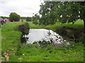
3
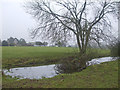
Sheep wash near Charlton Farm
A field has a watery dip in the middle of it. No sheep were seen bathing in it, though.
Image: © Neil Owen
Taken: 27 Dec 2019
0.08 miles
4
Boundary stone by the big tree
On Charlton Drive, a large tree and a somewhat smaller boundary stone. See Image] for a closer look at the latter.
Image: © Neil Owen
Taken: 27 Dec 2019
0.09 miles
5
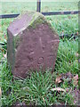
Boundary stone on Charlton Drive
A small but neat boundary stone near the Children's South West Hospice. See Image] for a wider look.
Image: © Neil Owen
Taken: 27 Dec 2019
0.10 miles
7
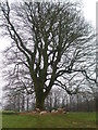
Sheltering under bare branches
Some sheep have a preference for cover underneath a wintry tree. A little dry hay makes a bit of a difference, too.
Image: © Neil Owen
Taken: 27 Dec 2019
0.11 miles
8
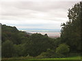
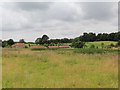
Grazing meadow with fine views to Priors Wood , the Bristol Channel and Wales beyond
Image: © Dr Duncan Pepper
Taken: 24 Sep 2010
0.13 miles
9

Ordnance Survey Cut Mark
This OS cut mark can be found on the west angle of Charlton House. It marks a point 36.037m above mean sea level.
Image: © Adrian Dust
Taken: 31 Jul 2022
0.16 miles
10
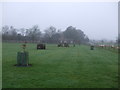
Downs School grounds
Despite the damp and gloom, the school's well-prepared grounds are an attractive feature, located beside a sheep field as they are.
Image: © Neil Owen
Taken: 27 Dec 2019
0.19 miles