IMAGES TAKEN NEAR TO
Charlton Drive, BRISTOL, BS48 1PD
Introduction
This page details the photographs taken nearby to Charlton Drive, BS48 1PD by members of the Geograph project.
The Geograph project started in 2005 with the aim of publishing, organising and preserving representative images for every square kilometre of Great Britain, Ireland and the Isle of Man.

There are currently over 7.5m images from over14,400 individuals and you can help contribute to the project by visiting https://www.geograph.org.uk
Image Map (Loading...)


Getting Data...Please wait
Leaflet Map data © OpenStreetMap
Images are licensed for reuse under creativecommons.org/licenses/by-sa/2.0
Notes
- Clicking on the map will re-center to the selected point.
- The higher the marker number, the further away the image location is from the centre of the postcode.
Image Listing (15 Images Found)
Images are licensed for reuse under creativecommons.org/licenses/by-sa/2.0
Image
Details
Distance
1

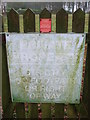
Ordnance Survey Cut Mark
This faint OS cut mark can be found on No49 Charlton Drive. It marks a point 147.916m above mean sea level.
Image: © Adrian Dust
Taken: 31 Jul 2022
0.01 miles
2
An old path re-routed
The new path makes a short skip around a small paddock now. Judging by the weathering the old path seems to be just that. Happily, the new route was well signed.
Image: © Neil Owen
Taken: 27 Dec 2019
0.08 miles
3
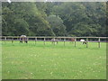
Equestrian facilities with donkeys and llamas
Image: © Dr Duncan Pepper
Taken: 24 Sep 2010
0.09 miles
4
Young animals and wild children
The Charlton Drive leads to the Downs School.
Image: © Neil Owen
Taken: 27 Dec 2019
0.13 miles
5
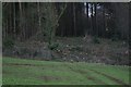
Woodsmoke in the woods
A hint of occupation near the entrance to Charlton Drive.
Image: © Neil Owen
Taken: 27 Dec 2019
0.15 miles
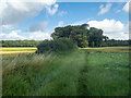
7
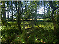
An isolated stretch of dilapidated boundary fence
Within this clump of trees at ST492729 Image, and marked on the 1:25000 OS map, there is c.100m isolated stretch of boundary fence, running approximately WSW to ENE. Only the posts remain, but the stile is still there, completely unnecessary. The clump, and its fence, is a mystery to me. A right of way runs through it.
Image: © Neville Goodman
Taken: 26 Jul 2020
0.18 miles
8
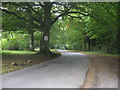
Charlton Drive-the road to the Downs School
Image: © Dr Duncan Pepper
Taken: 24 Sep 2010
0.18 miles
9
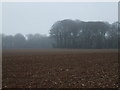
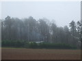
Misty field on the Gordano Round
The trees near Breach Wood are slipping into the damp mist.
Image: © Neil Owen
Taken: 27 Dec 2019
0.20 miles
10
Copse isolated from surrounding woodland
This clump of trees, seen on a misty day in Image and Image, is marked on OS maps going back to the 1880s. It was presumably once part of the labelled Breach Wood that partly encircles, from NW to SSE, the large field in which it stands. An isolated fence runs through it Image The path is marked as a right of way.
Image: © Neville Goodman
Taken: 26 Jul 2020
0.20 miles