IMAGES TAKEN NEAR TO
Tyntesfield, Wraxall, BRISTOL, BS48 1PB
Introduction
This page details the photographs taken nearby to BS48 1PB by members of the Geograph project.
The Geograph project started in 2005 with the aim of publishing, organising and preserving representative images for every square kilometre of Great Britain, Ireland and the Isle of Man.

There are currently over 7.5m images from over14,400 individuals and you can help contribute to the project by visiting https://www.geograph.org.uk
Image Map
Images are licensed for reuse under creativecommons.org/licenses/by-sa/2.0
Notes
- Clicking on the map will re-center to the selected point.
- The higher the marker number, the further away the image location is from the centre of the postcode.
Image Listing (5 Images Found)
Images are licensed for reuse under creativecommons.org/licenses/by-sa/2.0
Image
Details
Distance
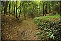
1
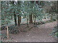
Paths meet in The Sidelands
Woodland near Tyntesfield House has a few paths running through it, some public.
Image: © Neil Owen
Taken: 10 Mar 2022
0.15 miles
2
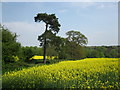
Pine tree
A single pine tree stands out between the fields of oil seed rape.
Image: © don cload
Taken: 21 Apr 2011
0.15 miles
4
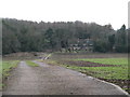
Footpath through Sidelands
Footpath through woodland above Wraxall.
Image: © Philip Halling
Taken: 10 Sep 2011
0.19 miles