IMAGES TAKEN NEAR TO
Wraxall, BRISTOL, BS48 1LR
Introduction
This page details the photographs taken nearby to BS48 1LR by members of the Geograph project.
The Geograph project started in 2005 with the aim of publishing, organising and preserving representative images for every square kilometre of Great Britain, Ireland and the Isle of Man.

There are currently over 7.5m images from over14,400 individuals and you can help contribute to the project by visiting https://www.geograph.org.uk
Image Map
Images are licensed for reuse under creativecommons.org/licenses/by-sa/2.0
Notes
- Clicking on the map will re-center to the selected point.
- The higher the marker number, the further away the image location is from the centre of the postcode.
Image Listing (17 Images Found)
Images are licensed for reuse under creativecommons.org/licenses/by-sa/2.0
Image
Details
Distance
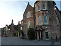
1
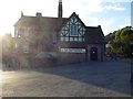
Open only to offers
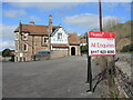
The Battleaxes pub in Wraxall was the last one left serving in the village until Covid hit. Having closed under lockdown, the owners went into administration and so the boards are out. Plans are being contended for converting the pub into private dwellings, but locals have protested in force. Quite what will happen is up in the air presently, but anyone with around £1 million are invited to call by.
Image: © Neil Owen
Taken: 10 Mar 2022
0.06 miles
2
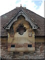
A detail on Battleaxe Cottages
Part of the scheme when the Battleaxes pub was built.
Image: © Neil Owen
Taken: 10 Mar 2022
0.06 miles
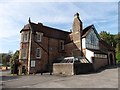
3
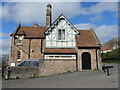
The Battleaxes pub in Wraxall
Built by local landowners the Gibbs family, for the benefit of the people of the village - a lot of whom worked for his lordship. It was originally called the Chequers Inn. The pub has had a chequered history of late and is currently up for sale. See Image] for a benchmark on the corner.
Image: © Neil Owen
Taken: 10 Mar 2022
0.07 miles
4
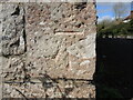
Battleaxe benchmark
A cutmark, as listed in the Benchmark Database: https://www.bench-marks.org.uk/bm63122 , on the corner of the pub in Wraxall. See Image] for a wider look.
Image: © Neil Owen
Taken: 10 Mar 2022
0.07 miles
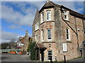
5
The Battleaxes, Wraxall
Large country house converted to a nice pub on the B3130 at Wraxall.
Image: © Steve Barnes
Taken: 9 Aug 2011
0.07 miles
7
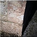
Ordnance Survey Cut Mark
This OS cut mark can be found on the Public House. It marks a point 39.572m above mean sea level.
Image: © Adrian Dust
Taken: 16 Mar 2020
0.07 miles
8
Back of the Battleaxes
Facing south is the rear of the pub. It was the gift to the village by Matilda Blanche Gibbs, widow of wealthy local merchant William Gibbs, in 1881. She opened it as a temperance house called the Chequers Inn. It later became the Widdecombe Inn before a more recent name-change.
Image: © Neil Owen
Taken: 10 Mar 2022
0.07 miles
9
Rear view of The Battleaxes
View of Image showing its country house origins.
Image: © Steve Barnes
Taken: 9 Aug 2011
0.07 miles
10
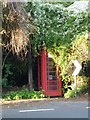
The disappearance of a Wraxall Phonebox
I know people moan that they can never find a phone box but I gather that this phonebox on the B3130 hasn't been used much lately.
Image: © Steve Barnes
Taken: 9 Aug 2011
0.08 miles