IMAGES TAKEN NEAR TO
Tower House Lane, BRISTOL, BS48 1JX
Introduction
This page details the photographs taken nearby to Tower House Lane, BS48 1JX by members of the Geograph project.
The Geograph project started in 2005 with the aim of publishing, organising and preserving representative images for every square kilometre of Great Britain, Ireland and the Isle of Man.

There are currently over 7.5m images from over14,400 individuals and you can help contribute to the project by visiting https://www.geograph.org.uk
Image Map (Loading...)


Getting Data...Please wait
Leaflet Map data © OpenStreetMap
Images are licensed for reuse under creativecommons.org/licenses/by-sa/2.0
Notes
- Clicking on the map will re-center to the selected point.
- The higher the marker number, the further away the image location is from the centre of the postcode.
Image Listing (9 Images Found)
Images are licensed for reuse under creativecommons.org/licenses/by-sa/2.0
Image
Details
Distance
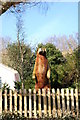

3

Ordnance Survey Cut Mark
This OS cut mark can be found on the wall SW side of the road. It marks a point 33.748m above mean sea level.
Image: © Adrian Dust
Taken: 31 Jul 2022
0.19 miles
4
Diverting off Stoney Steep
A footpath crosses Stoney Steep, a short road that will shortly cease being a road. Heading west, the re-routed path is part of the Nailsea Round path.
Image: © Neil Owen
Taken: 10 Mar 2022
0.19 miles
5

Ordnance Survey Cut Mark
This OS cut mark can be found on the wall south side of the road. It marks a point 94.372m above mean sea level.
Image: © Adrian Dust
Taken: 31 Jul 2022
0.20 miles
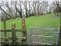
6

Ordnance Survey Rivet
This OS rivet can be found on the gatepost at the track road junction. It marks a point 60.960m above mean sea level.
Image: © Adrian Dust
Taken: 31 Jul 2022
0.22 miles
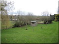
8
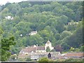
Birdcombe Court from a Distance
Also known as "The Tower House" - Home of the Coathupe family from 1793.
Image: © Steve Barnes
Taken: 20 Jul 2009
0.24 miles
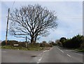
9
Off Ham Lane
Trees have been deliberately planted to provide some shelter.
Image: © Neil Owen
Taken: 10 Mar 2022
0.25 miles