IMAGES TAKEN NEAR TO
Yelverton Road, BRISTOL, BS4 5HP
Introduction
This page details the photographs taken nearby to Yelverton Road, BS4 5HP by members of the Geograph project.
The Geograph project started in 2005 with the aim of publishing, organising and preserving representative images for every square kilometre of Great Britain, Ireland and the Isle of Man.

There are currently over 7.5m images from over14,400 individuals and you can help contribute to the project by visiting https://www.geograph.org.uk
Image Map
Images are licensed for reuse under creativecommons.org/licenses/by-sa/2.0
Notes
- Clicking on the map will re-center to the selected point.
- The higher the marker number, the further away the image location is from the centre of the postcode.
Image Listing (42 Images Found)
Images are licensed for reuse under creativecommons.org/licenses/by-sa/2.0
Image
Details
Distance
1
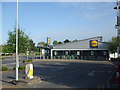
Brislington Lidl
A recent expansion for the now high-profile discount supermarket here on the A4 junction. The store stands on what used to be the Crittal metal windows factory of the post-war era.
Image: © Neil Owen
Taken: 26 Apr 2020
0.04 miles
2
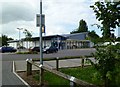
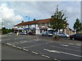
Brislington, supermarket
Lidl, at the corner of Bath Road and West Town Lane.
Image: © Mike Faherty
Taken: 19 Jul 2011
0.05 miles
3
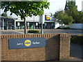
Just a Lidl further
Difficult to say this without a dodgy German accent, no?
Image: © Neil Owen
Taken: 26 Apr 2020
0.07 miles
4
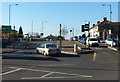
West Town Lane, Brislington, Bristol
Viewed across the A4 Bath Road.
Image: © Jaggery
Taken: 5 Nov 2012
0.07 miles
5
Food differs in the lockdown
These shops along West Town Lane demonstrate some essential differences of their operation during lockdown. The chippy on the left is shut whilst the pizza outlet is open - presumably due to the latter having a delivery service. Even the solicitor's shop has gone for good.
Image: © Neil Owen
Taken: 26 Apr 2020
0.08 miles
6
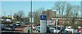
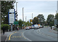
A4 into Brislington
Slow traffic in and out of the Bristol suburb, here passing a Hyundai showroom. Further along are the traffic lights at the junction with the A4174. In the background is Gilton House, sheltered council flats.
Image: © Derek Harper
Taken: 24 Feb 2016
0.08 miles
7
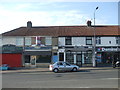
Brislington, shopping parade
On West Town Lane, comprising newsagents, tool hire shop, pizza shop, printshop, solicitors and café.
Image: © Mike Faherty
Taken: 19 Jul 2011
0.08 miles
8
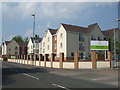
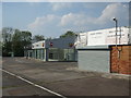
Arbour Walk
The new care home complex is a few years old but sits at the junction of Hungerford Road and Yelverton Road. Previously the site had been a post-war industrial area. One clue that it is a care home is the fact that the car park has a dedicated space for ambulance parking.
Image: © Neil Owen
Taken: 24 Apr 2020
0.09 miles
9
2010 : A4 Bath Road, Brislington, Bristol
Looking north west toward Bristol centre.
The traffic lights are at the top of Brislington Hill.
Note the schoolboy tripping his way home with a merry step. Not much has changed since Shakespeare's day.
Image: © Maurice Pullin
Taken: 28 Sep 2010
0.09 miles
10
A service of rust
The car dealers have moved out and all the motors are gone.
Image: © Neil Owen
Taken: 24 Apr 2020
0.10 miles