IMAGES TAKEN NEAR TO
West Town Park, BRISTOL, BS4 5ED
Introduction
This page details the photographs taken nearby to West Town Park, BS4 5ED by members of the Geograph project.
The Geograph project started in 2005 with the aim of publishing, organising and preserving representative images for every square kilometre of Great Britain, Ireland and the Isle of Man.

There are currently over 7.5m images from over14,400 individuals and you can help contribute to the project by visiting https://www.geograph.org.uk
Image Map
Images are licensed for reuse under creativecommons.org/licenses/by-sa/2.0
Notes
- Clicking on the map will re-center to the selected point.
- The higher the marker number, the further away the image location is from the centre of the postcode.
Image Listing (20 Images Found)
Images are licensed for reuse under creativecommons.org/licenses/by-sa/2.0
Image
Details
Distance
1
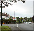
2010 : B3119 West Town Lane, Brislington
Crosses the Brislington Brook at the bottom of the hill.
Local schools have recently disgorged their charges. They were all so polite, found it most offputting. Made me feel old.
Image: © Maurice Pullin
Taken: 28 Sep 2010
0.06 miles
2
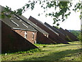
Gables down to the ground
An unusual style of architecture on West Town Lane. These houses were a relatively late addition to the housing stock as most of the rest on the road is Inter-war period.
Image: © Neil Owen
Taken: 26 Apr 2020
0.07 miles
3
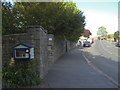
A library on the wall
Some self-help facilities on West Town Lane. See Image] for a closer look at the public spirited efforts.
Image: © Neil Owen
Taken: 26 Apr 2020
0.09 miles
4
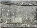
Old Bridge Marker beside West Town Lane
Bridge Marker set in the parapet of the bridge over Brislington Brook, on the southeast side of the B3119 West Town Lane, Bristol. Badly delaminated, but inscribed (….BRI(DGE / (….1)928 / (….1)958. See also https://www.geograph.org.uk/photo/6457394.
Milestone Society National ID: SO_BRIS29br
Image: © S Kosciow
Taken: 25 Aug 2022
0.09 miles
5
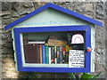
West Town Lane Free Library
What with all the local council cuts taking most public libraries out of action, some local positivity has provided this little chance for a good read. The note says that new donations will be cleansed before being put into the display, such are the necessities of the current pandemic. See Image] for a wider view.
Image: © Neil Owen
Taken: 26 Apr 2020
0.09 miles
6
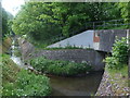
West Town Lane crossing the Brislington Brook
A large stone bridge carries the busy traffic along past the school as the brook slips underneath. A date stone in the middle of the southern parapet has been largely ruined by weathering, but the dates 1928 and 1957 are still legible - presumably the dates of building and rebuilding.
Image: © Neil Owen
Taken: 26 Apr 2020
0.09 miles
7
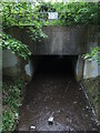
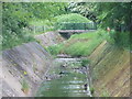
Repent and don't dump rubbish the water
The Brislington Brook is managed by a number of conduits, tunnels and pathways. Such a secluded spot is merely metres from the busy road, but affords the chance to dump old appliances in it. Others find it a place for evangelism.
Image: © Neil Owen
Taken: 12 May 2022
0.15 miles
8
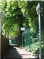
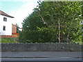
Up the side of the school
A lane allows scholars and their parents to access the school. It is fairly close to the original footpath that used to run across West Town Farm, which used to occupy the site that the school does now.
Image: © Neil Owen
Taken: 7 May 2020
0.15 miles
9
Two heads are wetter than one
The Brislington Brook joins forces here with another stream at the back of West Town Academy school. The long straight concrete channelling indicates how the brook has been re-directed when the area was being redeveloped in the post war era.
Image: © Neil Owen
Taken: 7 May 2020
0.16 miles
10
Basking on the brook
The Brislington Brook gently trickles along as the mallards bask, some on the embankment by the path.
Image: © Neil Owen
Taken: 7 May 2020
0.17 miles