IMAGES TAKEN NEAR TO
West Town Lane, BRISTOL, BS4 5DT
Introduction
This page details the photographs taken nearby to West Town Lane, BS4 5DT by members of the Geograph project.
The Geograph project started in 2005 with the aim of publishing, organising and preserving representative images for every square kilometre of Great Britain, Ireland and the Isle of Man.

There are currently over 7.5m images from over14,400 individuals and you can help contribute to the project by visiting https://www.geograph.org.uk
Image Map
Images are licensed for reuse under creativecommons.org/licenses/by-sa/2.0
Notes
- Clicking on the map will re-center to the selected point.
- The higher the marker number, the further away the image location is from the centre of the postcode.
Image Listing (27 Images Found)
Images are licensed for reuse under creativecommons.org/licenses/by-sa/2.0
Image
Details
Distance
1
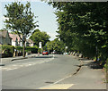
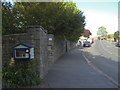
2009 : B3119 West Town Lane
Toward Brislington at the end of Sturminster Road.
The near sign warns of a school round the next bend.
Image: © Maurice Pullin
Taken: 7 Aug 2009
0.02 miles
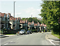
2
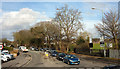
West Town Lane, Bristol
At the junction with Sturminster Road (to the right), with a sports ground on the right.
Image: © Derek Harper
Taken: 10 Mar 2018
0.05 miles
3
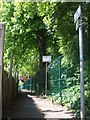
Up the side of the school
A lane allows scholars and their parents to access the school. It is fairly close to the original footpath that used to run across West Town Farm, which used to occupy the site that the school does now.
Image: © Neil Owen
Taken: 7 May 2020
0.06 miles
4
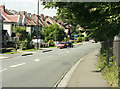
2009 : Sturminster Road looking north
At the foot of Flowers Hill (to the right) and Knowle Golf Course.
The blue sign gives warning of the mini roundabout at the junction of West Town Lane.
This is mostly housing of the 1920's and 30's though there is some modern infill.
Image: © Maurice Pullin
Taken: 7 Aug 2009
0.12 miles
5
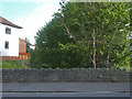
West Town Lane crossing the Brislington Brook
A large stone bridge carries the busy traffic along past the school as the brook slips underneath. A date stone in the middle of the southern parapet has been largely ruined by weathering, but the dates 1928 and 1957 are still legible - presumably the dates of building and rebuilding.
Image: © Neil Owen
Taken: 26 Apr 2020
0.13 miles
7
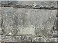
Old Bridge Marker beside West Town Lane
Bridge Marker set in the parapet of the bridge over Brislington Brook, on the southeast side of the B3119 West Town Lane, Bristol. Badly delaminated, but inscribed (….BRI(DGE / (….1)928 / (….1)958. See also https://www.geograph.org.uk/photo/6457394.
Milestone Society National ID: SO_BRIS29br
Image: © S Kosciow
Taken: 25 Aug 2022
0.13 miles
8

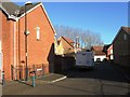
West Town Lane Free Library
What with all the local council cuts taking most public libraries out of action, some local positivity has provided this little chance for a good read. The note says that new donations will be cleansed before being put into the display, such are the necessities of the current pandemic. See Image] for a wider view.
Image: © Neil Owen
Taken: 26 Apr 2020
0.14 miles
9
A library on the wall
Some self-help facilities on West Town Lane. See Image] for a closer look at the public spirited efforts.
Image: © Neil Owen
Taken: 26 Apr 2020
0.15 miles
10
2009 : Sturminster Road, Knowle
1930's housing though this type of house was still being built in the 1950's.
The rather natty water tower on Totterdown can be seen.
Image: © Maurice Pullin
Taken: 7 Aug 2009
0.16 miles