IMAGES TAKEN NEAR TO
Callington Road, BRISTOL, BS4 5BW
Introduction
This page details the photographs taken nearby to Callington Road, BS4 5BW by members of the Geograph project.
The Geograph project started in 2005 with the aim of publishing, organising and preserving representative images for every square kilometre of Great Britain, Ireland and the Isle of Man.

There are currently over 7.5m images from over14,400 individuals and you can help contribute to the project by visiting https://www.geograph.org.uk
Image Map
Images are licensed for reuse under creativecommons.org/licenses/by-sa/2.0
Notes
- Clicking on the map will re-center to the selected point.
- The higher the marker number, the further away the image location is from the centre of the postcode.
Image Listing (90 Images Found)
Images are licensed for reuse under creativecommons.org/licenses/by-sa/2.0
Image
Details
Distance
1
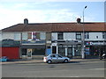
Food differs in the lockdown
These shops along West Town Lane demonstrate some essential differences of their operation during lockdown. The chippy on the left is shut whilst the pizza outlet is open - presumably due to the latter having a delivery service. Even the solicitor's shop has gone for good.
Image: © Neil Owen
Taken: 26 Apr 2020
0.05 miles
2
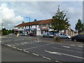
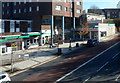
Brislington, shopping parade
On West Town Lane, comprising newsagents, tool hire shop, pizza shop, printshop, solicitors and café.
Image: © Mike Faherty
Taken: 19 Jul 2011
0.05 miles
3
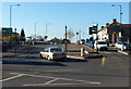
West Town Lane, Brislington, Bristol
Viewed across the A4 Bath Road.
Image: © Jaggery
Taken: 5 Nov 2012
0.06 miles
4
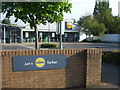
Just a Lidl further
Difficult to say this without a dodgy German accent, no?
Image: © Neil Owen
Taken: 26 Apr 2020
0.07 miles
5
Crossing the Brislington Brook
A small footbridge links the two inter-war suburban housing areas as the brook bisects them. However, this footbridge has a history that goes back well over a century to when all this was fields.
Image: © Neil Owen
Taken: 24 Apr 2020
0.08 miles
6
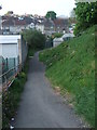
Dropping down off Callington Road
A small path leads down to the Brislington Brook and Kenneth Road.
Image: © Neil Owen
Taken: 24 Apr 2020
0.08 miles
7
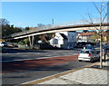
Brislington Hill footbridge, Bristol
The footbridge connects shops on the camera side with Runnymead Avenue
on the far side of the A4, here named Brislington Hill.
Image: © Jaggery
Taken: 5 Nov 2012
0.09 miles
8
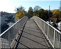
Across Brislington Hill footbridge, Bristol
The footbridge http://www.geograph.org.uk/photo/3508011 connects Runnymead Avenue on the left with shops alongside the A4 Brislington Hill.
Image: © Jaggery
Taken: 5 Nov 2012
0.09 miles
9
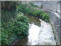
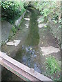
The Brislington Brook
The small stream rises not too far away but can generate some heavy flows - hence the pronounced use of concrete in this suburban area - but not in the current dry spell.
Image: © Neil Owen
Taken: 24 Apr 2020
0.09 miles
10
Brislington Hill shops near Gilton House, Bristol
The multi-storey Gilton House http://www.geograph.org.uk/photo/3507982 dominates this part of Brislington. Among the nearby shops is Get Knitted wool and crochet shop on the right at 39 Brislington Hill.
Image: © Jaggery
Taken: 5 Nov 2012
0.09 miles