IMAGES TAKEN NEAR TO
Broomhill Road, BRISTOL, BS4 4SD
Introduction
This page details the photographs taken nearby to Broomhill Road, BS4 4SD by members of the Geograph project.
The Geograph project started in 2005 with the aim of publishing, organising and preserving representative images for every square kilometre of Great Britain, Ireland and the Isle of Man.

There are currently over 7.5m images from over14,400 individuals and you can help contribute to the project by visiting https://www.geograph.org.uk
Image Map
Images are licensed for reuse under creativecommons.org/licenses/by-sa/2.0
Notes
- Clicking on the map will re-center to the selected point.
- The higher the marker number, the further away the image location is from the centre of the postcode.
Image Listing (12 Images Found)
Images are licensed for reuse under creativecommons.org/licenses/by-sa/2.0
Image
Details
Distance
1
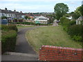
It's hall gone
This part of Broomhill Road is an open space and footpath down the back of the garages. As this area was being built post WWII, there was a club hall on this site but no trace remains of it now.
Image: © Neil Owen
Taken: 17 May 2020
0.09 miles
2
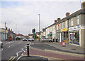
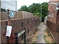
Broomhill, Bristol
The local shops on Broomhill Road, Brislington in Bristol.
Image: © Martin Clark
Taken: Unknown
0.11 miles
3
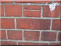
Benchmark on Jersey Avenue
A fine cutmark, as listed in the Benchmark Database: https://www.bench-marks.org.uk/bm121837 , on the wall in front of an electricity substation. See Image] for a wider view.
Image: © Neil Owen
Taken: 17 May 2020
0.12 miles
4
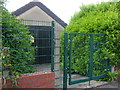
Electricity sub-station on Jersey Avenue
As part of the sprawling expansion of Bristol in the early post-WWII years, this sub-station was included before the houses were built. A benchmark can be seen in the brick wall - see Image
Image: © Neil Owen
Taken: 17 May 2020
0.12 miles
5
Lane close to Trig Point 1681
Surprisingly rural feel to this area
Image: © Damon Knight
Taken: 24 Aug 2007
0.14 miles
6
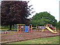
Eastwood Road play area
A play area for the young, one of the last parts of the Broomhill neighbourhood to be built post war.
Image: © Neil Owen
Taken: 17 May 2020
0.15 miles
7
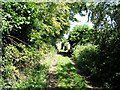
To Conham Ferry
The footpath off Eastwood Road takes visitors over the railway tunnel and down the steep slopes to the site of the old ferry.
Image: © Neil Owen
Taken: 17 May 2020
0.16 miles
8
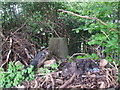
Buried at Belroyal Avenue
The lane running around the back of the houses here seem to be something of a free-for-all regarding tipping rubbish. This poor trig pillar is slowly becoming entombed. If exhumed, the flush bracket would show S3367.
Image: © Neil Owen
Taken: 1 May 2020
0.17 miles
9
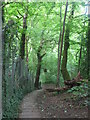
Dark, green and very steep
The terrain drops severely from the houses as it falls towards the River Avon, some 45m or more below in short order. The land right here is actually over the railway line - part of the G.W.R. line to Bath.
Image: © Neil Owen
Taken: 17 May 2020
0.20 miles
10
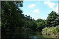
Railway running alongside the river Avon, entering Bristol
Image: © Martyn Pattison
Taken: 2 Aug 2005
0.21 miles