IMAGES TAKEN NEAR TO
Belroyal Avenue, BRISTOL, BS4 4RT
Introduction
This page details the photographs taken nearby to Belroyal Avenue, BS4 4RT by members of the Geograph project.
The Geograph project started in 2005 with the aim of publishing, organising and preserving representative images for every square kilometre of Great Britain, Ireland and the Isle of Man.

There are currently over 7.5m images from over14,400 individuals and you can help contribute to the project by visiting https://www.geograph.org.uk
Image Map
Images are licensed for reuse under creativecommons.org/licenses/by-sa/2.0
Notes
- Clicking on the map will re-center to the selected point.
- The higher the marker number, the further away the image location is from the centre of the postcode.
Image Listing (18 Images Found)
Images are licensed for reuse under creativecommons.org/licenses/by-sa/2.0
Image
Details
Distance
1
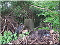
Buried at Belroyal Avenue
The lane running around the back of the houses here seem to be something of a free-for-all regarding tipping rubbish. This poor trig pillar is slowly becoming entombed. If exhumed, the flush bracket would show S3367.
Image: © Neil Owen
Taken: 1 May 2020
0.05 miles
2
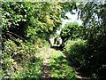
Lane close to Trig Point 1681
Surprisingly rural feel to this area
Image: © Damon Knight
Taken: 24 Aug 2007
0.06 miles
3
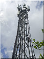
Broomhill mast
Looks like a mobile communications job, standing at the fringe of the houses and trading estate.
Image: © Neil Owen
Taken: 1 May 2020
0.08 miles
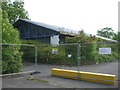
4
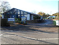
Brislington police station, Bristol
Located in Broomhill Road opposite Whitmore Avenue, the station is part of the Avon and Somerset Constabulary.
Image: © Jaggery
Taken: 5 Nov 2012
0.10 miles
5
Shut and locked for good
Broomhill Road police station closed its modern doors in 2016. The notices placed on the fences appear to indicate the site will be given over to new housing.
Image: © Neil Owen
Taken: 17 May 2020
0.10 miles
6
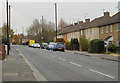
2010 : Approaching Broom Hill on Broomhill Road
North of Brislington.
Urban housing of the 1960's / 70's
Image: © Maurice Pullin
Taken: 26 Nov 2010
0.13 miles
7
It's hall gone
This part of Broomhill Road is an open space and footpath down the back of the garages. As this area was being built post WWII, there was a club hall on this site but no trace remains of it now.
Image: © Neil Owen
Taken: 17 May 2020
0.13 miles
8
2010 : Brrr! The postman comes to Condover Road
It was snowing that day by 5.00 p.m.
A turning off Broomhill Road, Bristol.
The housing looks to be 1960's / 70's.
Image: © Maurice Pullin
Taken: 26 Nov 2010
0.13 miles
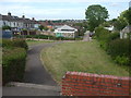
9
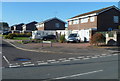
Regency Drive Bristol BS4
Houses on the north side of Regency Drive viewed from Broomhill Road in the Brislington area of Bristol.
Image: © Jaggery
Taken: 5 Nov 2012
0.16 miles
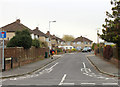
10
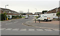
2010 : Regency Drive, Broom Hill, Bristol
A turning off Broomhill Road.
Image: © Maurice Pullin
Taken: 26 Nov 2010
0.17 miles