IMAGES TAKEN NEAR TO
Rochester Road, BRISTOL, BS4 4QQ
Introduction
This page details the photographs taken nearby to Rochester Road, BS4 4QQ by members of the Geograph project.
The Geograph project started in 2005 with the aim of publishing, organising and preserving representative images for every square kilometre of Great Britain, Ireland and the Isle of Man.

There are currently over 7.5m images from over14,400 individuals and you can help contribute to the project by visiting https://www.geograph.org.uk
Image Map
Images are licensed for reuse under creativecommons.org/licenses/by-sa/2.0
Notes
- Clicking on the map will re-center to the selected point.
- The higher the marker number, the further away the image location is from the centre of the postcode.
Image Listing (48 Images Found)
Images are licensed for reuse under creativecommons.org/licenses/by-sa/2.0
Image
Details
Distance
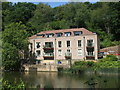
1
New homes on the former site of a pumping station
See Image for the view before.
Image: © Christine Johnstone
Taken: 23 Mar 2013
0.09 miles
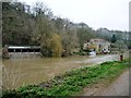
2
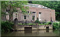
The old Conham Pumping Station
The large building was built in the mid-1950s alongside the St Annes Board Mills. However, its use came to and end and has been redeveloped into residential use. Quite a spot!
Image: © Neil Owen
Taken: 30 Jul 2020
0.09 miles
3
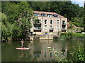
A relaxing way to traverse the Avon
Paddleboarding seems to be very popular these days: a proponent gracefully passes the former pumping station.
Image: © Neil Owen
Taken: 30 Jul 2020
0.09 miles
4
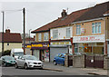
2010 : Row of shops in Birchwood Road, St. Annes's Park
Fish and chips this end, general store the other, but the fitness centre in the middle, is that double entendre or what?
Image: © Maurice Pullin
Taken: 26 Nov 2010
0.09 miles
5
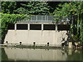
Birchwood weir
The resting ducks seem happy to sit in front of it; there's no sign of a sudden torrent.
Image: © Neil Owen
Taken: 30 Jul 2020
0.11 miles
6
Derelict Pumping Station, above St Anne's Park
On the left bank below the rowing club.
Image: © Pierre Terre
Taken: 20 May 2006
0.11 miles
7
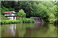
River Avon, above St Anne's Park
Boathouse and sluice, looking downstream by BARC boathouse
Image: © Pierre Terre
Taken: 20 May 2006
0.11 miles
8
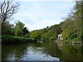
River Avon at Birch Wood
Looking upstream towards the former pumping station.
Image: © Christine Johnstone
Taken: 4 May 2015
0.11 miles
10
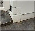
Ordnance Survey Cut Mark
This OS cut mark can be found on No26 Birchwood Road. It marks a point 45.476m above mean sea level.
Image: © Adrian Dust
Taken: 22 Apr 2022
0.12 miles