IMAGES TAKEN NEAR TO
Allison Road, BRISTOL, BS4 4PN
Introduction
This page details the photographs taken nearby to Allison Road, BS4 4PN by members of the Geograph project.
The Geograph project started in 2005 with the aim of publishing, organising and preserving representative images for every square kilometre of Great Britain, Ireland and the Isle of Man.

There are currently over 7.5m images from over14,400 individuals and you can help contribute to the project by visiting https://www.geograph.org.uk
Image Map
Images are licensed for reuse under creativecommons.org/licenses/by-sa/2.0
Notes
- Clicking on the map will re-center to the selected point.
- The higher the marker number, the further away the image location is from the centre of the postcode.
Image Listing (26 Images Found)
Images are licensed for reuse under creativecommons.org/licenses/by-sa/2.0
Image
Details
Distance
1
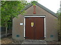
Sherwell Road sub-station
This little hut appears to have a couple of trees planted in its 'garden'.
Image: © Neil Owen
Taken: 1 May 2020
0.06 miles
2
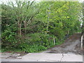
Not a busy footpath
This is a private lane with - apparently - a public footpath running alongside it. There doesn't seem to be a recognisable route in among the undergrowth. Speaking to a local resident it may be many decades since the council looked into it.
Image: © Neil Owen
Taken: 1 May 2020
0.06 miles
3
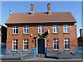
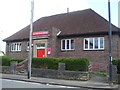
Brislington & St. Anne's Conservative Club
The Club was purpose-built in 1907/1908 by the Brislington & St. Anne's Unionist Club Company Limited. The land was purchased from the Clayfield-Ireland family, local landowners, at that time.
Image: © Pete Yeates
Taken: 21 Mar 2007
0.09 miles
4
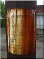
A good lick of preservative
A public notice attached to this new telegraph pole has become part of the preservation.
Image: © Neil Owen
Taken: 1 May 2020
0.10 miles
5
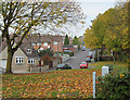
2010 : Hill Lawn, Brislington
Seen from the green area near Brislington Brook.
A fairly recent development.
Image: © Maurice Pullin
Taken: 7 Nov 2010
0.11 miles
6
Wick Road library
A post-war library at the junction of Wick Road and Allison Road, closed at the present due to the lockdown.
Image: © Neil Owen
Taken: 1 May 2020
0.11 miles
7
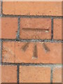
Ordnance Survey Cut Mark
This OS cut mark can be found on the club on Wick Road. It marks a point 47.570m above mean sea level.
Image: © Adrian Dust
Taken: 22 Apr 2022
0.11 miles
8
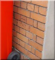
Conservative benchmark
A cutmark, as listed in the Benchmark Database: https://www.bench-marks.org.uk/bm92601 , on the Conservative Club in Wick Road. See Image] for a wider view.
Image: © Neil Owen
Taken: 1 May 2020
0.11 miles
9
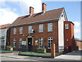
Brislington and St Annes Conservative Club
The club was founded in the early twentieth century and occupied some open ground initially. As Brislington grew the houses began to encroach, but the Ruskin Hall that was built next door at a later date was then demolished for new housing. Ironically, the Labour Party used it often for meetings. To the rear was the St John's Ambulance hall.
See Image] for a benchmark on the Con Club.
Image: © Neil Owen
Taken: 1 May 2020
0.11 miles
10
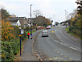
2010 : Sherwell Road, Brislington
Speed cameras abound even on these suburban roads.
Image: © Maurice Pullin
Taken: 7 Nov 2010
0.12 miles