IMAGES TAKEN NEAR TO
Allison Avenue, BRISTOL, BS4 4PB
Introduction
This page details the photographs taken nearby to Allison Avenue, BS4 4PB by members of the Geograph project.
The Geograph project started in 2005 with the aim of publishing, organising and preserving representative images for every square kilometre of Great Britain, Ireland and the Isle of Man.

There are currently over 7.5m images from over14,400 individuals and you can help contribute to the project by visiting https://www.geograph.org.uk
Image Map
Images are licensed for reuse under creativecommons.org/licenses/by-sa/2.0
Notes
- Clicking on the map will re-center to the selected point.
- The higher the marker number, the further away the image location is from the centre of the postcode.
Image Listing (13 Images Found)
Images are licensed for reuse under creativecommons.org/licenses/by-sa/2.0
Image
Details
Distance
1
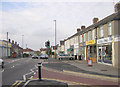
Broomhill, Bristol
The local shops on Broomhill Road, Brislington in Bristol.
Image: © Martin Clark
Taken: Unknown
0.12 miles
2
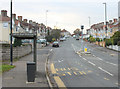
2010 : Bus shelter on Allison Road, Brislington
Ladman Road and Stockwood Road - on the end of the shelter - are both nearly two miles to the south, probably the terminus of the bus route.
Another speed camera.
Image: © Maurice Pullin
Taken: 7 Nov 2010
0.14 miles
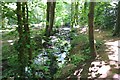
3
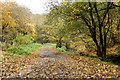
2010 : The Brislington Brook in autumn
In the past I have said some hard words about Bristol's treatment of its waterways, the Malago in Bedminster for example. A mere two miles from the city centre this almost makes up for the neglect and official vandalism elsewhere.
Image: © Maurice Pullin
Taken: 7 Nov 2010
0.15 miles
4
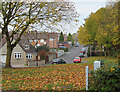
2010 : Hill Lawn, Brislington
Seen from the green area near Brislington Brook.
A fairly recent development.
Image: © Maurice Pullin
Taken: 7 Nov 2010
0.19 miles
5
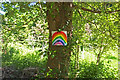
Support for the NHS
Nightingale Valley
Image: © Anthony O'Neil
Taken: 20 May 2020
0.20 miles
6
Streamside Walk
The Brislington Brook passes through on its way to the River Avon. Some of the houses on the left are part of an older rural settlement, separate from Brislington, called Rock. The road on the other side of the brook is now named in its honour.
Image: © Neil Owen
Taken: 1 May 2020
0.21 miles
7
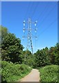
Power transmission lines
Brislington Brook
Image: © Anthony O'Neil
Taken: 20 May 2020
0.22 miles
8
Brislington Brook
Nightingale Valley
Image: © Anthony O'Neil
Taken: 20 May 2020
0.22 miles
9
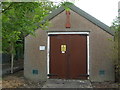
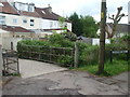
Sherwell Road sub-station
This little hut appears to have a couple of trees planted in its 'garden'.
Image: © Neil Owen
Taken: 1 May 2020
0.22 miles
10
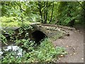
Brislington Nightingale Valley
Bridge over the Brislington Brook
Image: © norman griffin
Taken: 5 Sep 2015
0.22 miles