1
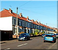
Houses on the west side of Pendennis Park, Brislington, Bristol
Viewed from the Montrose Park end looking towards Trelawney Park.
Image: © Jaggery
Taken: 5 Nov 2012
0.07 miles
2
2010 : Sherwell Road, Brislington
Speed cameras abound even on these suburban roads.
Image: © Maurice Pullin
Taken: 7 Nov 2010
0.09 miles
3
Brislington old fire station
Brislington old fire station, Hollywood Road, Brislington, Avon
Image: © Kevin Hale
Taken: 21 Mar 2010
0.09 miles
4
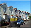
Sunshine and shadow, Bellevue Park, Brislington, Bristol
Viewed from Hollywood Road looking along Bellevue Park towards Bellevue Terrace.
Image: © Jaggery
Taken: 5 Nov 2012
0.11 miles
5
Zigzag roof pattern, Bellevue Terrace, Brislington, Bristol
A view north from the corner of Fry's Hill. http://www.geograph.org.uk/photo/3511458
Image: © Jaggery
Taken: 5 Nov 2012
0.11 miles
6
Edna Avenue
Image: © don cload
Taken: 28 Feb 2019
0.12 miles
7
A good lick of preservative
A public notice attached to this new telegraph pole has become part of the preservation.
Image: © Neil Owen
Taken: 1 May 2020
0.12 miles
8
Not a busy footpath
This is a private lane with - apparently - a public footpath running alongside it. There doesn't seem to be a recognisable route in among the undergrowth. Speaking to a local resident it may be many decades since the council looked into it.
Image: © Neil Owen
Taken: 1 May 2020
0.12 miles
9
Old school buildings
Carved in stone over the central windows "Wick Road Council Schools".
Image: © don cload
Taken: 28 Feb 2019
0.12 miles
10
Sherwell Road sub-station
This little hut appears to have a couple of trees planted in its 'garden'.
Image: © Neil Owen
Taken: 1 May 2020
0.12 miles


