IMAGES TAKEN NEAR TO
Bankside Road, BRISTOL, BS4 4LB
Introduction
This page details the photographs taken nearby to Bankside Road, BS4 4LB by members of the Geograph project.
The Geograph project started in 2005 with the aim of publishing, organising and preserving representative images for every square kilometre of Great Britain, Ireland and the Isle of Man.

There are currently over 7.5m images from over14,400 individuals and you can help contribute to the project by visiting https://www.geograph.org.uk
Image Map
Images are licensed for reuse under creativecommons.org/licenses/by-sa/2.0
Notes
- Clicking on the map will re-center to the selected point.
- The higher the marker number, the further away the image location is from the centre of the postcode.
Image Listing (93 Images Found)
Images are licensed for reuse under creativecommons.org/licenses/by-sa/2.0
Image
Details
Distance
1
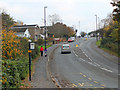
2010 : Sherwell Road, Brislington
Speed cameras abound even on these suburban roads.
Image: © Maurice Pullin
Taken: 7 Nov 2010
0.07 miles
2
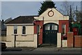
Brislington old fire station
Brislington old fire station, Hollywood Road, Brislington, Avon
Image: © Kevin Hale
Taken: 21 Mar 2010
0.08 miles
4
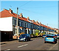
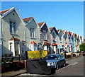
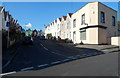
Houses on the west side of Pendennis Park, Brislington, Bristol
Viewed from the Montrose Park end looking towards Trelawney Park.
Image: © Jaggery
Taken: 5 Nov 2012
0.09 miles
5
A good lick of preservative
A public notice attached to this new telegraph pole has become part of the preservation.
Image: © Neil Owen
Taken: 1 May 2020
0.10 miles
6
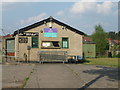
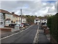
5th Bristol St Luke's Bristol Scouts' hut
Welcome to the Wigwam! Except that it's shut due to the Covid-19 lockdown.
Image: © Neil Owen
Taken: 24 Apr 2020
0.11 miles
7
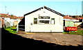
The Wigwam scout hut, Brislington, Bristol
Located in a locked, fenced-off compound at the NE end of Brookside Road,
The Wigwam scout hut is home to the 5th Bristol St Lukes Scout Group.
Image: © Jaggery
Taken: 5 Nov 2012
0.11 miles
8
Zigzag roof pattern, Bellevue Terrace, Brislington, Bristol
A view north from the corner of Fry's Hill. http://www.geograph.org.uk/photo/3511458
Image: © Jaggery
Taken: 5 Nov 2012
0.11 miles
9
Sunshine and shadow, Bellevue Park, Brislington, Bristol
Viewed from Hollywood Road looking along Bellevue Park towards Bellevue Terrace.
Image: © Jaggery
Taken: 5 Nov 2012
0.11 miles
10
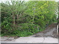
Not a busy footpath
This is a private lane with - apparently - a public footpath running alongside it. There doesn't seem to be a recognisable route in among the undergrowth. Speaking to a local resident it may be many decades since the council looked into it.
Image: © Neil Owen
Taken: 1 May 2020
0.11 miles