IMAGES TAKEN NEAR TO
Grove Park Road, BRISTOL, BS4 4JH
Introduction
This page details the photographs taken nearby to Grove Park Road, BS4 4JH by members of the Geograph project.
The Geograph project started in 2005 with the aim of publishing, organising and preserving representative images for every square kilometre of Great Britain, Ireland and the Isle of Man.

There are currently over 7.5m images from over14,400 individuals and you can help contribute to the project by visiting https://www.geograph.org.uk
Image Map
Images are licensed for reuse under creativecommons.org/licenses/by-sa/2.0
Notes
- Clicking on the map will re-center to the selected point.
- The higher the marker number, the further away the image location is from the centre of the postcode.
Image Listing (107 Images Found)
Images are licensed for reuse under creativecommons.org/licenses/by-sa/2.0
Image
Details
Distance
1
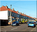
Houses on the west side of Pendennis Park, Brislington, Bristol
Viewed from the Montrose Park end looking towards Trelawney Park.
Image: © Jaggery
Taken: 5 Nov 2012
0.05 miles
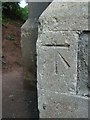
2
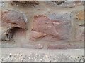
Ordnance Survey Cut Mark
This almost eroded OS cut mark can be found on the south face of the school on Eton Road. It marks a point 46.043m above mean sea level.
Image: © Adrian Dust
Taken: 22 Apr 2022
0.06 miles
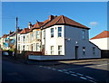
3
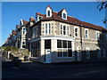
Montrose House, Brislington, Bristol
On the corner of Montrose Park and Grove Park Road. Viewed from Grove Park Avenue.
Image: © Jaggery
Taken: 5 Nov 2012
0.07 miles
4
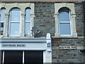
Three Montroses
Comparison at the end of a road that was named Montrose Avenue originally pre-war.
Image: © Neil Owen
Taken: 24 Apr 2020
0.08 miles
5
Corner of Montrose Park and Pendennis Park, Brislington, Bristol
Montrose Park is on the left, Pendennis Park on the right.
Image: © Jaggery
Taken: 5 Nov 2012
0.08 miles
6
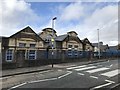
Old school buildings
Carved in stone over the central windows "Wick Road Council Schools".
Image: © don cload
Taken: 28 Feb 2019
0.08 miles
7
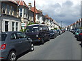
The Romans have long gone
This is Winchester Road, Brislington. At first glance it is a perfectly typical nineteenth century street, but as the houses were being developed in 1899 the excavations brought up Roman articles. The consequential archaeology revealed an interesting villa, probably built around 270 A.D. and one of many like it in the Bristol area. It featured about ten room, a bath with a hypocaust and signs of a metal-working shop.
Image: © Neil Owen
Taken: 1 May 2020
0.09 miles
8
Benchmark on the Brislington U.R.C.
A good cutmark on the old church; see https://www.bench-marks.org.uk/bm87860 for the entry in the Benchmark Database and Image] for a wider view.
Image: © Neil Owen
Taken: 24 Apr 2020
0.09 miles
9
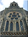
Looking up at the church windows
Brislington U.R.C. has a fine west face. It was built as a Congregational chapel before becoming the U.R.C. it is today. On the north-west corner is a benchmark - see Image
The church itself began as a movement in 1796 and local meetings were held near the inn down the road. A small stone building was built by local man Thomas James but that became overcrowded. By 1881 there were enough people to form what was called the United Christian Church Brislington, along with an associated Sunday School. A fire in 1894 damaged the original chapel, which was rebuilt but the reorganisation of city boundaries (Brislington was previously a separate village from Bristol) encouraged the worshippers to build a far bigger church here in 1901.
The Congregational Church became the United Reformed Church in 1972.
Image: © Neil Owen
Taken: 24 Apr 2020
0.09 miles
10
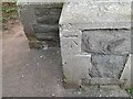
Ordnance Survey Cut Mark
This OS cut mark can be found on the NW angle of the church on Grove Park. It marks a point 43.309m above mean sea level.
Image: © Adrian Dust
Taken: 22 Apr 2022
0.09 miles