IMAGES TAKEN NEAR TO
Wick Road, BRISTOL, BS4 4HS
Introduction
This page details the photographs taken nearby to Wick Road, BS4 4HS by members of the Geograph project.
The Geograph project started in 2005 with the aim of publishing, organising and preserving representative images for every square kilometre of Great Britain, Ireland and the Isle of Man.

There are currently over 7.5m images from over14,400 individuals and you can help contribute to the project by visiting https://www.geograph.org.uk
Image Map
Images are licensed for reuse under creativecommons.org/licenses/by-sa/2.0
Notes
- Clicking on the map will re-center to the selected point.
- The higher the marker number, the further away the image location is from the centre of the postcode.
Image Listing (20 Images Found)
Images are licensed for reuse under creativecommons.org/licenses/by-sa/2.0
Image
Details
Distance
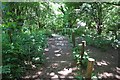
2
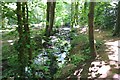
Brislington Brook
Nightingale Valley
Image: © Anthony O'Neil
Taken: 20 May 2020
0.11 miles
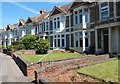
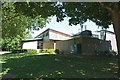
3
Wick Road houses at Collin Road junction
Image: © Roger Templeman
Taken: 2 May 2017
0.12 miles
4
Support for the NHS
Nightingale Valley
Image: © Anthony O'Neil
Taken: 20 May 2020
0.14 miles
5
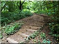
Brislington Brook
Steps leading down from Wick Road
Image: © norman griffin
Taken: 5 Sep 2015
0.14 miles
6
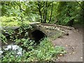
Brislington Nightingale Valley
Bridge over the Brislington Brook
Image: © norman griffin
Taken: 5 Sep 2015
0.15 miles
8
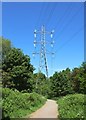
Power transmission lines
Brislington Brook
Image: © Anthony O'Neil
Taken: 20 May 2020
0.15 miles
10
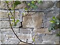
Ordnance Survey Cut Mark
This almost eroded OS cut mark can be found on the wall east side of Wick Road. It marks a point 41.709m above mean sea level.
Image: © Adrian Dust
Taken: 22 Apr 2022
0.16 miles