IMAGES TAKEN NEAR TO
Wick Road, BRISTOL, BS4 4HF
Introduction
This page details the photographs taken nearby to Wick Road, BS4 4HF by members of the Geograph project.
The Geograph project started in 2005 with the aim of publishing, organising and preserving representative images for every square kilometre of Great Britain, Ireland and the Isle of Man.

There are currently over 7.5m images from over14,400 individuals and you can help contribute to the project by visiting https://www.geograph.org.uk
Image Map
Images are licensed for reuse under creativecommons.org/licenses/by-sa/2.0
Notes
- Clicking on the map will re-center to the selected point.
- The higher the marker number, the further away the image location is from the centre of the postcode.
Image Listing (54 Images Found)
Images are licensed for reuse under creativecommons.org/licenses/by-sa/2.0
Image
Details
Distance
1
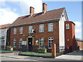
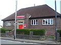
Brislington and St Annes Conservative Club
The club was founded in the early twentieth century and occupied some open ground initially. As Brislington grew the houses began to encroach, but the Ruskin Hall that was built next door at a later date was then demolished for new housing. Ironically, the Labour Party used it often for meetings. To the rear was the St John's Ambulance hall.
See Image] for a benchmark on the Con Club.
Image: © Neil Owen
Taken: 1 May 2020
0.02 miles
2
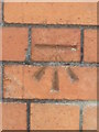
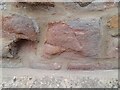
Conservative benchmark
A cutmark, as listed in the Benchmark Database: https://www.bench-marks.org.uk/bm92601 , on the Conservative Club in Wick Road. See Image] for a wider view.
Image: © Neil Owen
Taken: 1 May 2020
0.02 miles
3
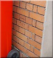
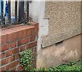
Ordnance Survey Cut Mark
This OS cut mark can be found on the club on Wick Road. It marks a point 47.570m above mean sea level.
Image: © Adrian Dust
Taken: 22 Apr 2022
0.02 miles
4
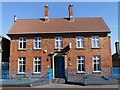
Brislington & St. Anne's Conservative Club
The Club was purpose-built in 1907/1908 by the Brislington & St. Anne's Unionist Club Company Limited. The land was purchased from the Clayfield-Ireland family, local landowners, at that time.
Image: © Pete Yeates
Taken: 21 Mar 2007
0.04 miles
5
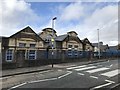
Wick Road library
A post-war library at the junction of Wick Road and Allison Road, closed at the present due to the lockdown.
Image: © Neil Owen
Taken: 1 May 2020
0.05 miles
6
Old school buildings
Carved in stone over the central windows "Wick Road Council Schools".
Image: © don cload
Taken: 28 Feb 2019
0.07 miles
7
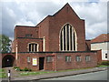
St Cuthbert's, Brislington
The church is an all brick affair, designed by P. Hartland Thomas in 1932. Previously, a temporary corrugated iron church stood near the spot, along with the St Cuthbert's Institute. See Image] for a look at the distinctive doorway.
Image: © Neil Owen
Taken: 1 May 2020
0.09 miles
8
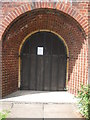
Brickwork arches
The side doorway of St Cuthbert's church shows a solid wooden door, heavy ironwork and the range of brick arches. The church was designed by P. Hartland Thomas in 1932.
Image: © Neil Owen
Taken: 1 May 2020
0.09 miles
9
Ordnance Survey Cut Mark
This almost eroded OS cut mark can be found on the south face of the school on Eton Road. It marks a point 46.043m above mean sea level.
Image: © Adrian Dust
Taken: 22 Apr 2022
0.10 miles
10
Ordnance Survey Cut Mark
This OS cut mark can be found on No107 Repton Road. It marks a point 33.940m above mean sea level.
Image: © Adrian Dust
Taken: 22 Apr 2022
0.12 miles