IMAGES TAKEN NEAR TO
Ivy May Close, BRISTOL, BS4 4FR
Introduction
This page details the photographs taken nearby to Ivy May Close, BS4 4FR by members of the Geograph project.
The Geograph project started in 2005 with the aim of publishing, organising and preserving representative images for every square kilometre of Great Britain, Ireland and the Isle of Man.

There are currently over 7.5m images from over14,400 individuals and you can help contribute to the project by visiting https://www.geograph.org.uk
Image Map
Images are licensed for reuse under creativecommons.org/licenses/by-sa/2.0
Notes
- Clicking on the map will re-center to the selected point.
- The higher the marker number, the further away the image location is from the centre of the postcode.
Image Listing (42 Images Found)
Images are licensed for reuse under creativecommons.org/licenses/by-sa/2.0
Image
Details
Distance
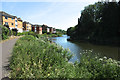
1
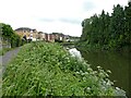
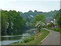
Quayside Lane
Housing beside the River Avon below St George, with the River Avon Trail and Monarch's Way following the river downstream. The path on the right leads to Quayside Lane and Crewshole Road.
Image: © Derek Harper
Taken: 13 Jul 2013
0.11 miles
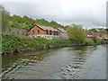
2
Quayside Village, River Avon, Crew's Hole
Downwind of Bristol, this area was long home to noxious chemical industries. The housing development on the right bank is the former site of the Crew's Hole Tar Works.
Image: © Pierre Terre
Taken: 20 May 2006
0.11 miles
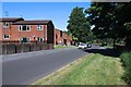
3
River Avon passing St Annes Park, Bristol
Image: © Martyn Pattison
Taken: 2 Aug 2005
0.12 miles
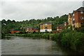
4
River Avon looking towards Crew's Hole
Now a quiet stretch of riverbank used by walkers and cyclists but a century and more ago a scene of intense industrial activity. For example, where new housing stands on the eastern bank below Trooper's Hill, there was a large tar distillery which produced preservatives for the wooden sleepers used by Brunel's Great Western Railway and later became a major chemical works.
Image: © Anthony O'Neil
Taken: 29 Apr 2011
0.14 miles
5
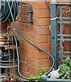
Ordnance Survey Cut Mark
This OS cut mark can be found on No47 Guildford Road. It marks a point 42.779m above mean sea level.
Image: © Adrian Dust
Taken: 22 Apr 2022
0.14 miles
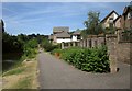
7
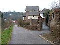
Footpath up to Butlers Walk
On the north-east bank of the Avon, a former industrial site.
Image: © Christine Johnstone
Taken: 23 Mar 2013
0.15 miles
8
Riverside buildings off Butlers Wharf
On the east bank of the River Avon.
Image: © Christine Johnstone
Taken: 3 May 2015
0.15 miles
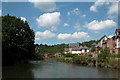
9
River Avon - upstream
Below Troopers Hill
Image: © Anthony O'Neil
Taken: 28 May 2020
0.16 miles