IMAGES TAKEN NEAR TO
Langton Court Road, BRISTOL, BS4 4EG
Introduction
This page details the photographs taken nearby to Langton Court Road, BS4 4EG by members of the Geograph project.
The Geograph project started in 2005 with the aim of publishing, organising and preserving representative images for every square kilometre of Great Britain, Ireland and the Isle of Man.

There are currently over 7.5m images from over14,400 individuals and you can help contribute to the project by visiting https://www.geograph.org.uk
Image Map
Images are licensed for reuse under creativecommons.org/licenses/by-sa/2.0
Notes
- Clicking on the map will re-center to the selected point.
- The higher the marker number, the further away the image location is from the centre of the postcode.
Image Listing (63 Images Found)
Images are licensed for reuse under creativecommons.org/licenses/by-sa/2.0
Image
Details
Distance
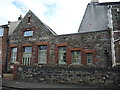
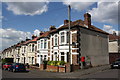
1
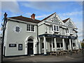
The Langton
A large pub formerly known as the Langton Court, handily placed on Langton Court Road. In fact, the original Langton Court was a private house in what was up until the late nineteenth century a rural area and slightly to the west of the present buildings. That house was turned over to a hotel but was demolished and the current built in 1902. See Image] for some of the detail.
Image: © Neil Owen
Taken: 2 Feb 2022
0.02 miles
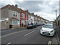
2
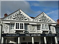
Edwardian style in St Anne's
The pub was built in 1902 and features plenty of style associated with that time. See Image] for a wider view of the pub.
Image: © Neil Owen
Taken: 2 Feb 2022
0.02 miles
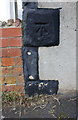
3
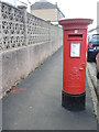
Letterbox on Highworth Road
A Georgian example, standing in a road that was previously called Addison Road before the Second World War.
Image: © Neil Owen
Taken: 2 Feb 2022
0.06 miles
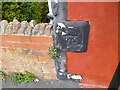
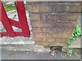
4
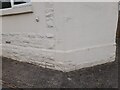
Ordnance Survey Cut Mark
This OS cut mark can be found on No102 Newbridge Road. It marks a point 29.035m above mean sea level.
Image: © Adrian Dust
Taken: 22 Apr 2022
0.06 miles
5
St Anne's Adult School
A school of an earlier age, tucked into an odd angle along Langton Court Road and dating from the early 1900s.
Image: © Neil Owen
Taken: 2 Feb 2022
0.07 miles
7
Benchmark on #61 Arlington Road (Langton Court Road face)
Ordnance Survey cut mark benchmark described on the Bench Mark Database at http://www.bench-marks.org.uk/bm84266
Image: © Roger Templeman
Taken: 2 May 2017
0.09 miles
8
Ordnance Survey Cut Mark
This OS cut mark can be found on No61 Arlington Road. It marks a point 31.809m above mean sea level.
Image: © Adrian Dust
Taken: 22 Apr 2022
0.09 miles
9
Junction of Arlington Road and Langton Court Road
There is an OS benchmark Image on the corner of the near house, on a black quoin, left of the post box.
Image: © Roger Templeman
Taken: 2 May 2017
0.10 miles
10
Ordnance Survey Cut Mark
This OS cut mark can be found on the wall of No178 Newbridge Road. It marks a point 31.251m above mean sea level.
Image: © Adrian Dust
Taken: 22 Apr 2022
0.10 miles