IMAGES TAKEN NEAR TO
Riverside Court, BRISTOL, BS4 4AY
Introduction
This page details the photographs taken nearby to Riverside Court, BS4 4AY by members of the Geograph project.
The Geograph project started in 2005 with the aim of publishing, organising and preserving representative images for every square kilometre of Great Britain, Ireland and the Isle of Man.

There are currently over 7.5m images from over14,400 individuals and you can help contribute to the project by visiting https://www.geograph.org.uk
Image Map
Images are licensed for reuse under creativecommons.org/licenses/by-sa/2.0
Notes
- Clicking on the map will re-center to the selected point.
- The higher the marker number, the further away the image location is from the centre of the postcode.
Image Listing (55 Images Found)
Images are licensed for reuse under creativecommons.org/licenses/by-sa/2.0
Image
Details
Distance
1
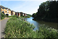
River Avon - upstream
Below Troopers Hill
Image: © Anthony O'Neil
Taken: 28 May 2020
0.06 miles
2
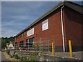
Woodwise Academy
This training establishment, run by Didac, is beside the River Avon Trail / Monarch's Way, with the river on the left.
Image: © Derek Harper
Taken: 13 Jul 2013
0.07 miles
4
River Avon Trail at Crew's Hole
The River Avon Trail / Monarch's Way runs along the right bank of the river as it curves around an incised meander. The new housing on the right is at Butler's Close.
Image: © Derek Harper
Taken: 13 Jul 2013
0.08 miles
5
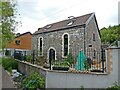
Converted Wesleyan Chapel, Crew's Hole
Image: © Roger Cornfoot
Taken: 7 Jun 2021
0.08 miles
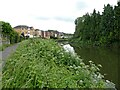
6
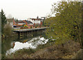
2010 : The Bristol Avon near Crew's Hole
The wharf almost opposite formerly belonged to the St.Anne's Board Mills which was located immediately behind. Seen from downstream in Image] the wharf was built to receive woodpulp imported from into Bristol Docks from Norway Sweden and Finland and brought up the river by barge.
There is a drawing of the site from a different angle in 1925 http://www.baph.org.uk/imagepages/quarterly/q50p22.htm
St. Anne's Board Mills was opened in 1911 by the Imperial Tobacco Company to produce packaging for its cigarettes. http://www.thisisbristol.co.uk/news/packaging-firm-folded/article-360112-detail/article.html
Image: © Maurice Pullin
Taken: 26 Nov 2010
0.09 miles
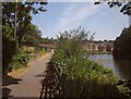
7
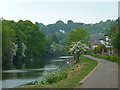
River Avon looking towards Crew's Hole
Now a quiet stretch of riverbank used by walkers and cyclists but a century and more ago a scene of intense industrial activity. For example, where new housing stands on the eastern bank below Trooper's Hill, there was a large tar distillery which produced preservatives for the wooden sleepers used by Brunel's Great Western Railway and later became a major chemical works.
Image: © Anthony O'Neil
Taken: 29 Apr 2011
0.09 miles
8
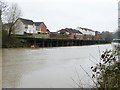
Homes off Wyatts View
At a former industrial quayside on the River Avon. The nearest white home is empty and boarded up.
Image: © Christine Johnstone
Taken: 23 Mar 2013
0.10 miles
10
Access to Woodland path and steps to Trooper's Hill
Image: © Roger Cornfoot
Taken: 7 Jun 2021
0.10 miles