IMAGES TAKEN NEAR TO
Braikenridge Road, BRISTOL, BS4 3SW
Introduction
This page details the photographs taken nearby to Braikenridge Road, BS4 3SW by members of the Geograph project.
The Geograph project started in 2005 with the aim of publishing, organising and preserving representative images for every square kilometre of Great Britain, Ireland and the Isle of Man.

There are currently over 7.5m images from over14,400 individuals and you can help contribute to the project by visiting https://www.geograph.org.uk
Image Map
Images are licensed for reuse under creativecommons.org/licenses/by-sa/2.0
Notes
- Clicking on the map will re-center to the selected point.
- The higher the marker number, the further away the image location is from the centre of the postcode.
Image Listing (31 Images Found)
Images are licensed for reuse under creativecommons.org/licenses/by-sa/2.0
Image
Details
Distance
1
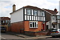
#224 Bloomfield Road at Buckingham Road junction
There is an OS benchmark Image on the side of the house under the Buckingham Road name sign
Image: © Roger Templeman
Taken: 2 May 2017
0.06 miles
2
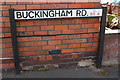
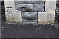
Benchmark on #224 Bloomfield Road on Buckingham Road face
Ordnance Survey cut mark benchmark described on the Bench Mark Database at http://www.bench-marks.org.uk/bm84269
Image: © Roger Templeman
Taken: 2 May 2017
0.06 miles
3
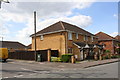
Wick Road houses at Collin Road junction
Image: © Roger Templeman
Taken: 2 May 2017
0.07 miles
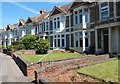
6
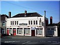
The Bloomfield Inn, Brislington
The Bloomfield Inn is at the junction of Sandholm Road and Bloomfield Road.
Image: © Pete Yeates
Taken: 1 Jun 2005
0.09 miles
7
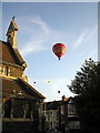
Langton Road Bristol
Balloons over St Annes
Image: © norman griffin
Taken: 8 Aug 2009
0.11 miles
8
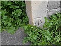
Ordnance Survey Cut Mark
This OS cut mark can be found on the SW angle of St Anne's Church. It marks a point 36.466m above mean sea level.
Image: © Adrian Dust
Taken: 22 Apr 2022
0.12 miles
9
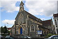
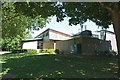
St Anne's Church, Langton Road
There is an OS benchmark Image on the buttress to the right of the blue door
Image: © Roger Templeman
Taken: 2 May 2017
0.12 miles
10
Benchmark on buttress of St Anne's Church
Ordnance Survey cut mark benchmark described on the Bench Mark Database at http://www.bench-marks.org.uk/bm84268
Image: © Roger Templeman
Taken: 2 May 2017
0.12 miles