IMAGES TAKEN NEAR TO
Repton Road, BRISTOL, BS4 3LT
Introduction
This page details the photographs taken nearby to Repton Road, BS4 3LT by members of the Geograph project.
The Geograph project started in 2005 with the aim of publishing, organising and preserving representative images for every square kilometre of Great Britain, Ireland and the Isle of Man.

There are currently over 7.5m images from over14,400 individuals and you can help contribute to the project by visiting https://www.geograph.org.uk
Image Map
Images are licensed for reuse under creativecommons.org/licenses/by-sa/2.0
Notes
- Clicking on the map will re-center to the selected point.
- The higher the marker number, the further away the image location is from the centre of the postcode.
Image Listing (44 Images Found)
Images are licensed for reuse under creativecommons.org/licenses/by-sa/2.0
Image
Details
Distance
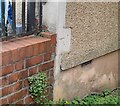
1
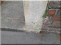
Ordnance Survey Cut Mark
This OS cut mark can be found on gatepost of No54 Repton Road. It marks a point 30.776m above mean sea level.
Image: © Adrian Dust
Taken: 22 Apr 2022
0.03 miles
3
Ordnance Survey Cut Mark
This OS cut mark can be found on the west angle of the Sandringham Hotel, Sandhurst Road. It marks a point 26.450m above mean sea level.
Image: © Adrian Dust
Taken: 22 Apr 2022
0.05 miles
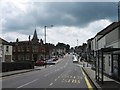
4
Brislington, Bristol
Looking east down Allison Road, Brislington, from near Wick Road towards Broomhill.
Image: © Martin Clark
Taken: Unknown
0.07 miles
5
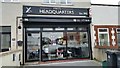
Mike's Headquarters
The last barbers shop in the road!
Image: © Pete Yeates
Taken: 24 Apr 2015
0.07 miles
6
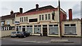
Bloomfield Inn
As at 4/5/2015, closed and up for sale
Image: © Pete Yeates
Taken: 24 Apr 2015
0.07 miles
7
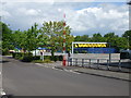
No more buses
This modern trading estate on the Bath Road in Brislington belies its past. Opening in the late nineteenth century, it was a place where heavy machinery made heavy vehicles. It was the Bristol Commercial Vehicles works that made the nationally-known Bristol bus chassis. Associated with the nearby tram depot and works, the B.C.V. site made completed buses until the post-war period. Once nationalisation dictated the operations of bus-making, the site simply made the chassis and sent them to Lowestoft - the E.C.W. works for completion. Once a running example was made, a driver (sitting on a bare frame and with no cab whatsoever!) took it all the way to East Anglia.
Image: © Neil Owen
Taken: 1 May 2020
0.08 miles
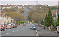
8
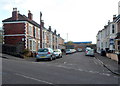
Stirling Road, Bristol
Viewed across Sandy Park Road.
Image: © Jaggery
Taken: 5 Nov 2012
0.09 miles
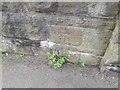
9
Ordnance Survey Cut Mark
This OS cut mark can be found on No107 Repton Road. It marks a point 33.940m above mean sea level.
Image: © Adrian Dust
Taken: 22 Apr 2022
0.11 miles
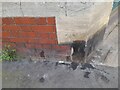
10
Ordnance Survey Cut Mark
This OS cut mark can be found on the wall SW side of Sandy Park Road. It marks a point 25.079m above mean sea level.
Image: © Adrian Dust
Taken: 22 Apr 2022
0.12 miles