IMAGES TAKEN NEAR TO
Bath Road, BRISTOL, BS4 3JZ
Introduction
This page details the photographs taken nearby to Bath Road, BS4 3JZ by members of the Geograph project.
The Geograph project started in 2005 with the aim of publishing, organising and preserving representative images for every square kilometre of Great Britain, Ireland and the Isle of Man.

There are currently over 7.5m images from over14,400 individuals and you can help contribute to the project by visiting https://www.geograph.org.uk
Image Map
Images are licensed for reuse under creativecommons.org/licenses/by-sa/2.0
Notes
- Clicking on the map will re-center to the selected point.
- The higher the marker number, the further away the image location is from the centre of the postcode.
Image Listing (53 Images Found)
Images are licensed for reuse under creativecommons.org/licenses/by-sa/2.0
Image
Details
Distance
1
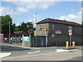
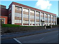
Two sorts of vets?
This area on the A4 in Brislington is home to a P.D.S.A. branch but also young military types. The Army Cadet Force and the Air Training Corps both have a base here too.
Originally this was the site of Kensington House, a large and opulent mansion built around 1810. It featured some top class kitchen facilities of the time and a very large garden. With Arnos Vale as next door neighbour, the grounds were extensively cultivated with unusual species. It became the home of a Richard Jenkins Poole-King, a wealthy Bristol merchant who was later voted as Lord Mayor in 1844.
The mansion changed hands a few times until a builder, George Lewis Poole, took over in 1902. He helped to develop the surrounding area as the gardens were reduced to feed the demand. By 1935, the house was used by St Christopher's church and then in 1937 a tank regiment of the Territorial Army occupied it. The military connections have survived to this day, and they occupy the coach house and stables we see overlooking the road. The house itself was eventually demolished in 1973.
Image: © Neil Owen
Taken: 1 May 2020
0.04 miles
2
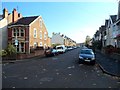
Hampstead Road, Bristol
Looking SSE from the corner of King's Road.
Image: © Jaggery
Taken: 5 Nov 2012
0.07 miles
3

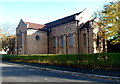
Entrance to St Christopher's Church, Brislington, Bristol
Anglican church viewed from Hampstead Road.
Image: © Jaggery
Taken: 5 Nov 2012
0.09 miles
4
SW side of St Christopher's Church, Brislington, Bristol
Anglican church viewed across Falfield Road.
Image: © Jaggery
Taken: 5 Nov 2012
0.10 miles
5
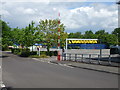
No more buses
This modern trading estate on the Bath Road in Brislington belies its past. Opening in the late nineteenth century, it was a place where heavy machinery made heavy vehicles. It was the Bristol Commercial Vehicles works that made the nationally-known Bristol bus chassis. Associated with the nearby tram depot and works, the B.C.V. site made completed buses until the post-war period. Once nationalisation dictated the operations of bus-making, the site simply made the chassis and sent them to Lowestoft - the E.C.W. works for completion. Once a running example was made, a driver (sitting on a bare frame and with no cab whatsoever!) took it all the way to East Anglia.
Image: © Neil Owen
Taken: 1 May 2020
0.11 miles
6
Former Tansad premises, Bath Road, Bristol
The derelict building is 493-499 Bath Road.
Image: © Jaggery
Taken: 5 Nov 2012
0.11 miles
7
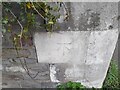
Ordnance Survey Cut Mark
This OS cut mark can be found on the wall NE side of Bath Road. It marks a point 24.832m above mean sea level.
Image: © Adrian Dust
Taken: 22 Apr 2022
0.11 miles
8
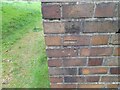
Ordnance Survey Cut Mark
This OS cut mark can be found on the south angle of St Christopher's Church. It marks a point 28.093m above mean sea level.
Image: © Adrian Dust
Taken: 22 Apr 2022
0.11 miles
9
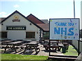
Shut but grateful
The pub has been forced to close, but thanks are made public.
Image: © Neil Owen
Taken: 1 May 2020
0.12 miles
10
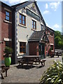
The Lodekka
Waiting patiently for the customers to return after the Covid-19 lockdown.
Image: © Neil Owen
Taken: 1 May 2020
0.12 miles