IMAGES TAKEN NEAR TO
Bath Road, BRISTOL, BS4 3JQ
Introduction
This page details the photographs taken nearby to Bath Road, BS4 3JQ by members of the Geograph project.
The Geograph project started in 2005 with the aim of publishing, organising and preserving representative images for every square kilometre of Great Britain, Ireland and the Isle of Man.

There are currently over 7.5m images from over14,400 individuals and you can help contribute to the project by visiting https://www.geograph.org.uk
Image Map
Images are licensed for reuse under creativecommons.org/licenses/by-sa/2.0
Notes
- Clicking on the map will re-center to the selected point.
- The higher the marker number, the further away the image location is from the centre of the postcode.
Image Listing (74 Images Found)
Images are licensed for reuse under creativecommons.org/licenses/by-sa/2.0
Image
Details
Distance
1
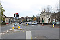
2010 : A4 at Arno's Gate, in the middle of the road
Looking along Bath Road, round the bend to the right and up the hill to Brislington. St. Philip's Causeway enters left followed by Sandy Park Road.
Arno's Gate, a turnpike gate on the Bath Road, stood on the inside of this bend.
And don't worry, the photographer was well protected by a bollard.
Image: © Maurice Pullin
Taken: 7 Nov 2010
0.06 miles
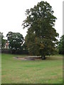
3
Southern entrance to Arnos Court Park, Bristol
From King's Road.
Image: © Jaggery
Taken: 5 Nov 2012
0.07 miles
4
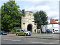
Ornate archway entrance to a depot in Brislington, Bristol
On the corner of Bath Road and Bloomfield Road. Some references show a bus depot here, but I think "former bus depot" is now correct. A notice on the wall shows that the maximum vehicle height under the arch is 4 metres - if alarm sounds you must stop immediately.
Image: © Jaggery
Taken: 5 Nov 2012
0.07 miles
5
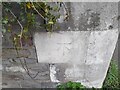
Ordnance Survey Cut Mark
This OS cut mark can be found on the wall NE side of Bath Road. It marks a point 24.832m above mean sea level.
Image: © Adrian Dust
Taken: 22 Apr 2022
0.07 miles
6
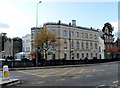
Arnos Manor Hotel, Bristol
Hotel, restaurant and bar viewed across the A4 Bath Road.
Image: © Jaggery
Taken: 5 Nov 2012
0.07 miles
7
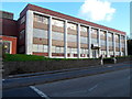
Former Tansad premises, Bath Road, Bristol
The derelict building is 493-499 Bath Road.
Image: © Jaggery
Taken: 5 Nov 2012
0.07 miles
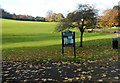
8
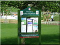
Notice board at Arnos Court, Bristol
Image: © Anthony O'Neil
Taken: 15 Mar 2011
0.08 miles
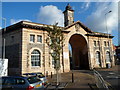
9
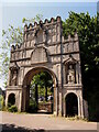
Arno's Court Triumphal Arch
Built in 1760, moved to this location in 1912.
Image: © Chris Andrews
Taken: 5 Jun 2023
0.08 miles
10
Arno's Court Triumphal Arch
On Bath Road, Brislington. This Grade II* listed arch is believed to be by James Bridges. It was originally the gateway to Arno's Castle, but was moved to the entrance to Arno's Court Bath House in 1912.
Image: © Eirian Evans
Taken: 23 Aug 2018
0.08 miles