IMAGES TAKEN NEAR TO
Runswick Road, BRISTOL, BS4 3HZ
Introduction
This page details the photographs taken nearby to Runswick Road, BS4 3HZ by members of the Geograph project.
The Geograph project started in 2005 with the aim of publishing, organising and preserving representative images for every square kilometre of Great Britain, Ireland and the Isle of Man.

There are currently over 7.5m images from over14,400 individuals and you can help contribute to the project by visiting https://www.geograph.org.uk
Image Map
Images are licensed for reuse under creativecommons.org/licenses/by-sa/2.0
Notes
- Clicking on the map will re-center to the selected point.
- The higher the marker number, the further away the image location is from the centre of the postcode.
Image Listing (61 Images Found)
Images are licensed for reuse under creativecommons.org/licenses/by-sa/2.0
Image
Details
Distance
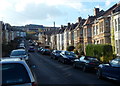
1
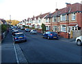
Runswick Road, Brislington, Bristol
Looking NNW from near the Kensington Park Road end of Runswick Road.
Image: © Jaggery
Taken: 5 Nov 2012
0.01 miles
2
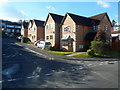
Queensdown Gardens, Brislington, Bristol
Viewed from Runswick Road.
Image: © Jaggery
Taken: 5 Nov 2012
0.03 miles
3
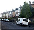
Runswick Road south of Falfield Road, Brislington, Bristol
Looking SSE towards Kensington Park Road.
Image: © Jaggery
Taken: 5 Nov 2012
0.04 miles
4
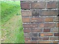
Ordnance Survey Cut Mark
This OS cut mark can be found on the south angle of St Christopher's Church. It marks a point 28.093m above mean sea level.
Image: © Adrian Dust
Taken: 22 Apr 2022
0.08 miles
5
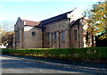
SW side of St Christopher's Church, Brislington, Bristol
Anglican church viewed across Falfield Road.
Image: © Jaggery
Taken: 5 Nov 2012
0.08 miles
6
Hampstead Road, Bristol
Looking SSE from the corner of King's Road.
Image: © Jaggery
Taken: 5 Nov 2012
0.08 miles
7

Entrance to St Christopher's Church, Brislington, Bristol
Anglican church viewed from Hampstead Road.
Image: © Jaggery
Taken: 5 Nov 2012
0.08 miles
8
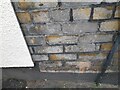
Ordnance Survey Cut Mark
This OS cut mark can be found on No48 Kensington Park Road. It marks a point 38.835m above mean sea level.
Image: © Adrian Dust
Taken: 22 Apr 2022
0.08 miles
9
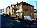
Tantra, Bristol
Apple Mac computer hardware retailer and support
at 48 Kensington Park Road, on the corner of Runswick Road.
Image: © Jaggery
Taken: 5 Nov 2012
0.08 miles
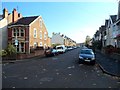
10
Car-lined Kensington Park Road, Bristol
Viewed from near the corner of Hampstead Road looking towards Lodway Road.
Image: © Jaggery
Taken: 5 Nov 2012
0.10 miles