IMAGES TAKEN NEAR TO
Hampstead Road, BRISTOL, BS4 3HR
Introduction
This page details the photographs taken nearby to Hampstead Road, BS4 3HR by members of the Geograph project.
The Geograph project started in 2005 with the aim of publishing, organising and preserving representative images for every square kilometre of Great Britain, Ireland and the Isle of Man.

There are currently over 7.5m images from over14,400 individuals and you can help contribute to the project by visiting https://www.geograph.org.uk
Image Map
Images are licensed for reuse under creativecommons.org/licenses/by-sa/2.0
Notes
- Clicking on the map will re-center to the selected point.
- The higher the marker number, the further away the image location is from the centre of the postcode.
Image Listing (62 Images Found)
Images are licensed for reuse under creativecommons.org/licenses/by-sa/2.0
Image
Details
Distance
1
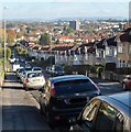
Talbot Road, Bristol
Looking east from a point roughly equidistant from the Buller Road and Lodway Road junctions.
Image: © Jaggery
Taken: 5 Nov 2012
0.05 miles
2
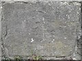
Ordnance Survey Cut Mark
This almost eroded OS cut mark can be found on north parapet of the railway bridge on Talbot Road. It marks a point 40.764m above mean sea level.
Image: © Adrian Dust
Taken: 22 Apr 2022
0.07 miles
3
Brislington, West Moor Lane, 1963
View NE, towards A4 Bath Road: not quite where Brislington station had been - see Image It shows well the commerce of the day, fifty years ago.
Image: © Ben Brooksbank
Taken: 12 Aug 1963
0.08 miles
4
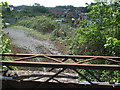
Old view from an old bridge
The land around Station Road is now a recycling and reclamation business. The Bristol and North Somerset railway line closed in 1973 and just beyond the diggers was the site of the old Brislington station.
Image: © Neil Owen
Taken: 1 May 2020
0.08 miles
5
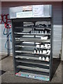
Scrap me please!
Some shop shelving is left outside of a closed (due to the lockdown?) shop with a request for it to be scrapped. Quite what anyone would do about that is another matter.
Image: © Neil Owen
Taken: 1 May 2020
0.08 miles
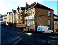
6
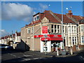
A traditional corner shop
The junction of Kensington Park Road and Hampstead Road is a favoured spot for a little local shop. The date stone marks 1912 as the beginning of the history of service.
Image: © Neil Owen
Taken: 1 May 2020
0.08 miles
7
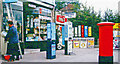
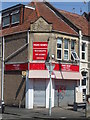
Park News, Kensington Park, Bristol
Newsagents, grocers and off-licence on the corner of Kensington Park Road and Hampstead Road.
Image: © Jaggery
Taken: 5 Nov 2012
0.08 miles
8
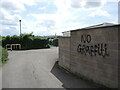
Wall irony
Someone has a certain sense of humour. At least they can spell properly.
Image: © Neil Owen
Taken: 19 May 2022
0.08 miles
9
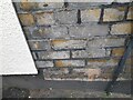
Ordnance Survey Cut Mark
This OS cut mark can be found on No48 Kensington Park Road. It marks a point 38.835m above mean sea level.
Image: © Adrian Dust
Taken: 22 Apr 2022
0.09 miles
10
Tantra, Bristol
Apple Mac computer hardware retailer and support
at 48 Kensington Park Road, on the corner of Runswick Road.
Image: © Jaggery
Taken: 5 Nov 2012
0.09 miles