IMAGES TAKEN NEAR TO
Chatsworth Road, BRISTOL, BS4 3EY
Introduction
This page details the photographs taken nearby to Chatsworth Road, BS4 3EY by members of the Geograph project.
The Geograph project started in 2005 with the aim of publishing, organising and preserving representative images for every square kilometre of Great Britain, Ireland and the Isle of Man.

There are currently over 7.5m images from over14,400 individuals and you can help contribute to the project by visiting https://www.geograph.org.uk
Image Map
Images are licensed for reuse under creativecommons.org/licenses/by-sa/2.0
Notes
- Clicking on the map will re-center to the selected point.
- The higher the marker number, the further away the image location is from the centre of the postcode.
Image Listing (149 Images Found)
Images are licensed for reuse under creativecommons.org/licenses/by-sa/2.0
Image
Details
Distance
1
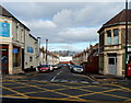
Chatsworth Road, Bristol BS4
Viewed across Bath Road. Curry House http://www.geograph.org.uk/photo/3878426 is on the left.
There are two Chatsworth Roads in Bristol. This one is in postal area BS4.
Image: © Jaggery
Taken: 8 Nov 2012
0.03 miles
2
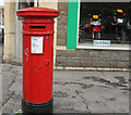
2010 : Victorian pillar box
Note the vandalism. The motorcycle shop behind is closed so there is no quick getaway.
Image: © Maurice Pullin
Taken: 7 Nov 2010
0.04 miles
3
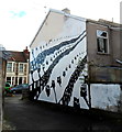
Edward Road house mural, Bristol
On the side wall of the house at the northern end of Edward Road.
The name in the lower right corner of the mural is SCOTT BUCHANAN BARDEN.
Image: © Jaggery
Taken: 8 Nov 2012
0.04 miles
4
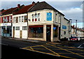
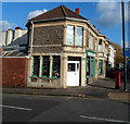
Curry House, Bristol
Curry House Indian restaurant and takeaway is at 393 Bath Road, on the corner of Chatsworth Road.
Image: © Jaggery
Taken: 8 Nov 2012
0.05 miles
5
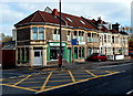
Aplins of Bristol
Moped and motor bike shop on the corner of Bath Road and Chatsworth Road.
Image: © Jaggery
Taken: 5 Nov 2012
0.06 miles
6
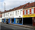
Bath Road Motorcycles and Bath Rd Massage, Bristol
Viewed across the A4 Bath Road.
Image: © Jaggery
Taken: 8 Nov 2012
0.06 miles
7
North side of Bath Road east of Chatsworth Road, Bristol
Aplins moped and motorbike shop (sales, service, spares) is on the corner.
Image: © Jaggery
Taken: 8 Nov 2012
0.06 miles
8
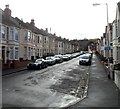
Edward Road towards Bath Road, Bristol
A footpath and cycleway sign on the right points towards Arnos Vale Cemetery.
Image: © Jaggery
Taken: 8 Nov 2012
0.06 miles
9
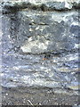
Benchmark on Bath Road wall of Arno's Vale Cemetery
Ordnance Survey cut mark benchmark described on the Bench Mark Database at http://www.bench-marks.org.uk/bm35350.
Image: © Roger Templeman
Taken: 28 Aug 2010
0.07 miles
10
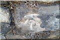
Ordnance Survey Cut Mark
This very worn OS cut mark can be found on the wall of Arnos Vale Cemetery. It marks a point 17.992m above mean sea level.
Image: © Adrian Dust
Taken: 4 Nov 2021
0.07 miles