IMAGES TAKEN NEAR TO
Bath Road, BRISTOL, BS4 3EW
Introduction
This page details the photographs taken nearby to Bath Road, BS4 3EW by members of the Geograph project.
The Geograph project started in 2005 with the aim of publishing, organising and preserving representative images for every square kilometre of Great Britain, Ireland and the Isle of Man.

There are currently over 7.5m images from over14,400 individuals and you can help contribute to the project by visiting https://www.geograph.org.uk
Image Map
Images are licensed for reuse under creativecommons.org/licenses/by-sa/2.0
Notes
- Clicking on the map will re-center to the selected point.
- The higher the marker number, the further away the image location is from the centre of the postcode.
Image Listing (138 Images Found)
Images are licensed for reuse under creativecommons.org/licenses/by-sa/2.0
Image
Details
Distance
1
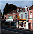
Pizza Magic in Bristol
Takeaway at 361 Bath Road.
Image: © Jaggery
Taken: 8 Nov 2012
0.01 miles
2
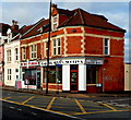
Scotty's Barber Shop, Bristol
369 Bath Road, on the corner of Edward Road.
Image: © Jaggery
Taken: 8 Nov 2012
0.02 miles
3
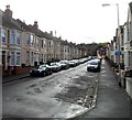
Edward Road towards Bath Road, Bristol
A footpath and cycleway sign on the right points towards Arnos Vale Cemetery.
Image: © Jaggery
Taken: 8 Nov 2012
0.02 miles
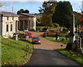
4
Arnos Vale Cemetery reception and gift shop, Bristol
Located on the south side of the A4 Bath Road, the cemetery was laid out as
an Arcadian landscape in the mid 1830s, with many classical style buildings.
Image: © Jaggery
Taken: 8 Nov 2012
0.03 miles
5
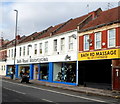
Bath Road Motorcycles and Bath Rd Massage, Bristol
Viewed across the A4 Bath Road.
Image: © Jaggery
Taken: 8 Nov 2012
0.03 miles
6
Path through the north side of Arnos Vale Cemetery, Bristol
Looking east from near the Soldiers' Corner. http://www.geograph.org.uk/photo/4483981
Image: © Jaggery
Taken: 8 Nov 2012
0.03 miles
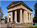
8
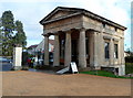
Greek Doric tetrastyle temples at the entrance to Arnos Vale Cemetery, Bristol
Viewed across the A4 Bath Road. Built in 1837-1838 as lodges in the Greek Revival style.
Image: © Jaggery
Taken: 5 Nov 2012
0.04 miles
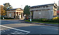
9
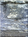
Benchmark on Bath Road wall of Arno's Vale Cemetery
Ordnance Survey cut mark benchmark described on the Bench Mark Database at http://www.bench-marks.org.uk/bm35350.
Image: © Roger Templeman
Taken: 28 Aug 2010
0.04 miles
10
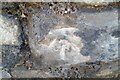
Ordnance Survey Cut Mark
This very worn OS cut mark can be found on the wall of Arnos Vale Cemetery. It marks a point 17.992m above mean sea level.
Image: © Adrian Dust
Taken: 4 Nov 2021
0.04 miles