IMAGES TAKEN NEAR TO
Bath Road, BRISTOL, BS4 3ED
Introduction
This page details the photographs taken nearby to Bath Road, BS4 3ED by members of the Geograph project.
The Geograph project started in 2005 with the aim of publishing, organising and preserving representative images for every square kilometre of Great Britain, Ireland and the Isle of Man.

There are currently over 7.5m images from over14,400 individuals and you can help contribute to the project by visiting https://www.geograph.org.uk
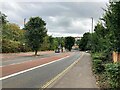
Image Map
Images are licensed for reuse under creativecommons.org/licenses/by-sa/2.0
Notes
- Clicking on the map will re-center to the selected point.
- The higher the marker number, the further away the image location is from the centre of the postcode.
Image Listing (310 Images Found)
Images are licensed for reuse under creativecommons.org/licenses/by-sa/2.0
Image
Details
Distance
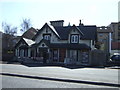
1
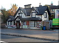
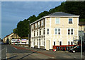
The Thunderbolt, Totterdown, Bristol
Located at 124 Bath Road. Formerly The Turnpike Inn dating from c1840. The distinctive external feature is 6 hexagonal chimney stacks joined by a continuous moulded cap.
The Thunderbolt's website describes their business as an independent music and arts venue which sells local ales, ciders and wines. With a capacity of 150, The Thunderbolt has become a circuit venue on the live music scene, considered an essential stop-off for many bands on their UK tours.
Image: © Jaggery
Taken: 5 Nov 2012
0.00 miles
2
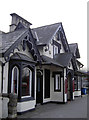
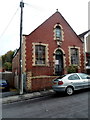
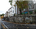
Once the Turnpike
This is now the Thunderbolt public house, a popular live music venue, although it was the Turnpike for most of its life.
The area of Totterdown was an important gateway to Bristol and the authorities erected a tollgate for users after the Act of 1748. The people were moved to tear them down, leading to some angry scenes and retribution. However, this pub is a Victorian Gothic style building that stands on the turnpike - hence its original name. The tolls were eventually dropped in 1863. Grade II listed.
Image: © Neil Owen
Taken: 10 Feb 2017
0.00 miles
5
Down Summer Hill, Totterdown, Bristol
Summer Hill descends towards the A4 Bath Road. A nearby sign shows a 25% gradient (1 in 4).
Image: © Jaggery
Taken: 8 Nov 2012
0.02 miles
6
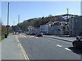
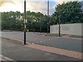
Bath Road View
A summer evening shot looking along Bristol's Bath Road.
Image: © Mary and Angus Hogg
Taken: 28 Jun 2018
0.03 miles
7
Unsafe building - keep out, Totterdown, Bristol
The former Church of the Nazarene, located at the bottom of Summer Hill,
viewed in early November 2012.
Image: © Jaggery
Taken: 8 Nov 2012
0.03 miles
8
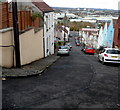
Hillside Street, Totterdown, Bristol
Looking east towards Summer Hill from the corner of Stanley Hill. http://www.geograph.org.uk/photo/4013342
Image: © Jaggery
Taken: 8 Nov 2012
0.03 miles
9
Bristol : Bath Road
Bath Road at the junction with Totterdown Bridge.
Image: © Lewis Clarke
Taken: 6 Aug 2020
0.04 miles