IMAGES TAKEN NEAR TO
Balmain Street, BRISTOL, BS4 3DB
Introduction
This page details the photographs taken nearby to Balmain Street, BS4 3DB by members of the Geograph project.
The Geograph project started in 2005 with the aim of publishing, organising and preserving representative images for every square kilometre of Great Britain, Ireland and the Isle of Man.

There are currently over 7.5m images from over14,400 individuals and you can help contribute to the project by visiting https://www.geograph.org.uk
Image Map
Images are licensed for reuse under creativecommons.org/licenses/by-sa/2.0
Notes
- Clicking on the map will re-center to the selected point.
- The higher the marker number, the further away the image location is from the centre of the postcode.
Image Listing (238 Images Found)
Images are licensed for reuse under creativecommons.org/licenses/by-sa/2.0
Image
Details
Distance
1
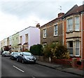
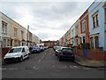
Change of house type, Balmain Street, Totterdown, Bristol
Most of the houses in Balmain Street are similar to the ones on the left.
The houses on the right are near the corner of Hawthorne Street.
Image: © Jaggery
Taken: 8 Nov 2012
0.01 miles
2
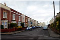
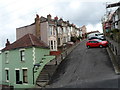
Balmain Street, Totterdown, Bristol
Looking NNW from Fordell Place along Balmain Street towards Vale Street.
Image: © Jaggery
Taken: 8 Nov 2012
0.03 miles
3
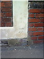
Benchmark on #1 Balmain Street (Fordell Place)
Ordnance Survey cut mark benchmark described on the Bench Mark Database at http://www.bench-marks.org.uk/bm35339.
Image: © Roger Templeman
Taken: 28 Aug 2010
0.03 miles
4
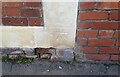
Ordnance Survey Cut Mark
This OS cut mark can be found on No1 Barmain Street. It marks a point 59.866m above mean sea level.
Image: © Adrian Dust
Taken: 4 Nov 2021
0.03 miles
5
Balmain Street, Totterdown, Bristol
From the corner of Vale Street looking towards Fordell Place and Hawthorne Street.
Image: © Jaggery
Taken: 8 Nov 2012
0.03 miles
6
Vale St, Arnos Vale
View across the steep sided valley from the children's playground in School Road.
Vale St runs up the hill side from Park St in the foreground to the junction with Arno's St in the background
Image: © Nigel Mykura
Taken: 4 Apr 2010
0.03 miles
7
Corner of Hawthorne Street and Fordell Place, Totterdown, Bristol
Hawthorne Street is on the left.
Image: © Jaggery
Taken: 8 Nov 2012
0.04 miles
8
Vale Street, Totterdown, Bristol
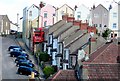
Viewed from Park Street looking up towards Upper Street and Arnos Street.
Totterdown has many steep streets. This part of Vale Street is the steepest one, and is a candidate for the steepest residential street in England. A sign at the top of the gradient shows 1 in 4 for the 80 metre descent. For the steepest section, the few metres in the foreground alongside the steps, one source states a gradient of 35% (1 in 2.86). Cars are parked sideways as a safety measure.
Image: © Jaggery
Taken: 8 Nov 2012
0.04 miles
9
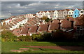
Totterdown rooftops, Bristol
Viewed from School Road Park.
Image: © Jaggery
Taken: 8 Nov 2012
0.04 miles
10
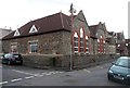
NW corner of Hillcrest Primary School, Totterdown, Bristol
On the corner of Fordell Place and Arnos Street.
Image: © Jaggery
Taken: 8 Nov 2012
0.04 miles