IMAGES TAKEN NEAR TO
Kingstree Street, BRISTOL, BS4 3AH
Introduction
This page details the photographs taken nearby to Kingstree Street, BS4 3AH by members of the Geograph project.
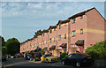
The Geograph project started in 2005 with the aim of publishing, organising and preserving representative images for every square kilometre of Great Britain, Ireland and the Isle of Man.

There are currently over 7.5m images from over14,400 individuals and you can help contribute to the project by visiting https://www.geograph.org.uk
Image Map
Images are licensed for reuse under creativecommons.org/licenses/by-sa/2.0
Notes
- Clicking on the map will re-center to the selected point.
- The higher the marker number, the further away the image location is from the centre of the postcode.
Image Listing (324 Images Found)
Images are licensed for reuse under creativecommons.org/licenses/by-sa/2.0
Image
Details
Distance
1
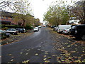
A leafy road and pavement in Bristol BS4
County Road in early November 2012.
Image: © Jaggery
Taken: 8 Nov 2012
0.01 miles
3
Welcome to Totterdown
Such an apt name, as this view shows the steep terrain close to the River Avon. Post-war this area was composed mainly of rows and rows of nineteenth century terraces, all clinging on to the hills. However, the planners decided to make a clean sweep of the city and improve on the work of the Luftwaffe. A scheme to create a big ringroad was begun with the bulldozer. Hundreds of homes were wiped off the map. However, the big scheme failed to materialise and the empty suburbs left as a memory. However, the council eventually made some amends in the 1980s by building this modern estate - a much more open and airy place to live than the terraces.
This is Angers Road and is based on the old original.
Image: © Neil Owen
Taken: 10 Feb 2017
0.04 miles
4
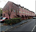
Highgrove Street houses, Totterdown, Bristol
A 60 metre long row of houses, built in the late 1990s, viewed from the corner of Stanley Hill.
Image: © Jaggery
Taken: 8 Nov 2012
0.04 miles
5
Highgrove Street
A row of modern houses in the Totterdown area of Bristol, viewed in summer evening sunshine.
Image: © Mary and Angus Hogg
Taken: 28 Jun 2018
0.04 miles
6
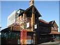
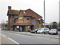
Repairing the Bush
Totterdown used to have a pub/hotel here in the distant past, called The Bush. It was demolished in the post-war planning scheme that was never copmleted. A new pub was built a few decades later on this spot (just up the road from the original). however, changing times and tastes forced it to close. It was then partly taken over as a nursery, but the building needs much repair.
Image: © Neil Owen
Taken: 27 May 2022
0.05 miles
7
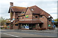
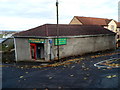
The Bush pub for sale, Bristol
There was a For Sale board on this Wells Road building at the early November 2012 date of this view. http://www.geograph.org.uk/photo/3583796 to a later view, in June 2013.
Image: © Jaggery
Taken: 8 Nov 2012
0.05 miles
8
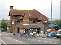
Another 'Last Orders'
The Bush in Totterdown was an old pub which was eventually demolished in June 1973 as part of the council's grand plan - a plan that never materialised other than the wholesale flattening of this community. The building here was opened in 1985 as a replacement, although it's a short distance from the original.
It had been hoped to rebuild this area (after completing a huge ring road system!) and this large pub was provided for the community. The obvious problem is that the people didn't return in the numbers expected and the Bush is expensive to run. Sadly it is now boarded up, just like so many others of a longer history.
Image: © Neil Owen
Taken: 28 Jun 2013
0.05 miles
9
Wessex Glass,Totterdown, Bristol
Occupying Unit 1 in Wessex Buildings, Stanley Hill, Wessex Glass are specialists
in UPVC windows and doors. The business also provides glazing services.
Image: © Jaggery
Taken: 8 Nov 2012
0.06 miles
10

Autumn leaves on Stanley Hill, Totterdown, Bristol
Viewed in early November.
Image: © Jaggery
Taken: 8 Nov 2012
0.06 miles