IMAGES TAKEN NEAR TO
Broadfield Road, BRISTOL, BS4 2UW
Introduction
This page details the photographs taken nearby to Broadfield Road, BS4 2UW by members of the Geograph project.
The Geograph project started in 2005 with the aim of publishing, organising and preserving representative images for every square kilometre of Great Britain, Ireland and the Isle of Man.

There are currently over 7.5m images from over14,400 individuals and you can help contribute to the project by visiting https://www.geograph.org.uk
Image Map
Images are licensed for reuse under creativecommons.org/licenses/by-sa/2.0
Notes
- Clicking on the map will re-center to the selected point.
- The higher the marker number, the further away the image location is from the centre of the postcode.
Image Listing (17 Images Found)
Images are licensed for reuse under creativecommons.org/licenses/by-sa/2.0
Image
Details
Distance
1
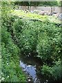
The brook at the back of Broadfield Road
Brislington Brook as it passes through Knowle.
Image: © Neil Owen
Taken: 7 May 2020
0.09 miles
2
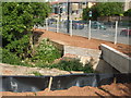
Keeping the brook in line
The recent major roadworks along the Airport Road has also included the alterations to the Brislington Brook and its minor tributary.
Image: © Neil Owen
Taken: 7 May 2020
0.16 miles
3
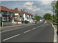
Only due to the lockdown
The A4174 Airport Road in south Bristol at a time when the traffic has been severely curbed during the lockdown. Only last year it was given a major reworking that caused congestion and delays for months.
Image: © Neil Owen
Taken: 7 May 2020
0.17 miles
4
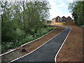
The path to a new home
The development on the Airport Road has already been completed in a few spots, or is very near at least.
Image: © Neil Owen
Taken: 12 May 2022
0.17 miles
5
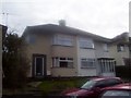
Semi-detached housing in Westleigh Park
Image: © peter clayton
Taken: 15 Feb 2010
0.17 miles
6
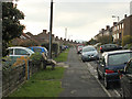
2010 : West on Ponsford Road, Knowle
The chairs were being given away.
Image: © Maurice Pullin
Taken: 7 Nov 2010
0.18 miles
7
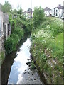
Approaching Bear's Bridge
The Brislington Brook on its way to the major road crossroads in Knowle. This area is an Inter-War development, as shown by the housing on the far side of the road, and the brook used to wander a little more than it does today.
Image: © Neil Owen
Taken: 7 May 2020
0.19 miles
8
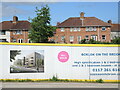
Changing the face of Knowle
The inter-war houses of Knowle cover many acres, but are now facing a new boklok on the block.
Image: © Neil Owen
Taken: 12 May 2022
0.19 miles
9
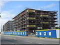
Big blocks by the brook
Airport Road is undergoing a massive development.
Image: © Neil Owen
Taken: 12 May 2022
0.20 miles
10
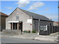
A dance hall on Hengrove Lane
A small hall is now used as a dance studio.
Image: © Neil Owen
Taken: 12 May 2022
0.20 miles