IMAGES TAKEN NEAR TO
Ponsford Road, BRISTOL, BS4 2UP
Introduction
This page details the photographs taken nearby to Ponsford Road, BS4 2UP by members of the Geograph project.
The Geograph project started in 2005 with the aim of publishing, organising and preserving representative images for every square kilometre of Great Britain, Ireland and the Isle of Man.

There are currently over 7.5m images from over14,400 individuals and you can help contribute to the project by visiting https://www.geograph.org.uk
Image Map
Images are licensed for reuse under creativecommons.org/licenses/by-sa/2.0
Notes
- Clicking on the map will re-center to the selected point.
- The higher the marker number, the further away the image location is from the centre of the postcode.
Image Listing (37 Images Found)
Images are licensed for reuse under creativecommons.org/licenses/by-sa/2.0
Image
Details
Distance
1
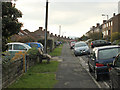
2010 : West on Ponsford Road, Knowle
The chairs were being given away.
Image: © Maurice Pullin
Taken: 7 Nov 2010
0.01 miles
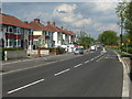
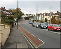
2
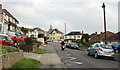
2010 : Ponsford Road, Knowle looking east
The learner motorcyclist makes his way to Wells Road.
Image: © Maurice Pullin
Taken: 7 Nov 2010
0.04 miles
3
Wells Road
Approaching the junction with the A4174 Airport Road
Image: © Eirian Evans
Taken: 11 Apr 2019
0.06 miles
4
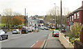
2010 : A37 Wells Road heading south out of Bristol
Toward Whitchurch and Pensford.
The A4174 crosses at the traffic lights, Airport Road to the right, Wootton Park leading to Callington Road to the left. The old Imperial Athletic Ground is on the other side of the trees to the left.
Image: © Maurice Pullin
Taken: 7 Nov 2010
0.06 miles
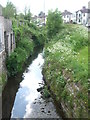
5
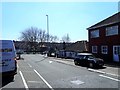
Sheltering near Bear's Bridge
The Wells Road/Airport Road intersection is a very busy junction in south Bristol. Close to the many traffic lights are a collection of utility cabinets, gas supplies and pollution monitors.
Image: © Neil Owen
Taken: 12 May 2022
0.09 miles
6
Only due to the lockdown
The A4174 Airport Road in south Bristol at a time when the traffic has been severely curbed during the lockdown. Only last year it was given a major reworking that caused congestion and delays for months.
Image: © Neil Owen
Taken: 7 May 2020
0.09 miles
7
Approaching Bear's Bridge
The Brislington Brook on its way to the major road crossroads in Knowle. This area is an Inter-War development, as shown by the housing on the far side of the road, and the brook used to wander a little more than it does today.
Image: © Neil Owen
Taken: 7 May 2020
0.10 miles
8
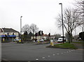
Major crossroads, A37 and Airport Road, Knowle
Image: © Roger Cornfoot
Taken: 18 Feb 2011
0.10 miles
9
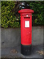
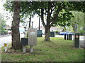
A Georgian postbox
At the end of Imperial Walk.
Image: © Neil Owen
Taken: 7 May 2020
0.10 miles
10
2010 : A37 Wells road heading for Bristol city centre
About two miles from the city centre via Knowle and Totterdown.
Image: © Maurice Pullin
Taken: 7 Nov 2010
0.11 miles