IMAGES TAKEN NEAR TO
Stoneleigh Crescent, BRISTOL, BS4 2RQ
Introduction
This page details the photographs taken nearby to Stoneleigh Crescent, BS4 2RQ by members of the Geograph project.
The Geograph project started in 2005 with the aim of publishing, organising and preserving representative images for every square kilometre of Great Britain, Ireland and the Isle of Man.

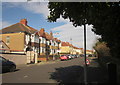
There are currently over 7.5m images from over14,400 individuals and you can help contribute to the project by visiting https://www.geograph.org.uk
Image Map
Images are licensed for reuse under creativecommons.org/licenses/by-sa/2.0
Notes
- Clicking on the map will re-center to the selected point.
- The higher the marker number, the further away the image location is from the centre of the postcode.
Image Listing (50 Images Found)
Images are licensed for reuse under creativecommons.org/licenses/by-sa/2.0
Image
Details
Distance
1
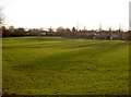
No game today
Not until the weekend. Redcatch Park football pitch can just be made out against the wintry sunlight. See Image] for the adjoining paths.
Image: © Neil Owen
Taken: 1 Feb 2012
0.09 miles
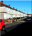
2
Stoneleigh Road, Knowle
A straight road with short terraces, seen from the junction shown in Image
Image: © Derek Harper
Taken: 15 Mar 2014
0.10 miles
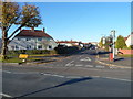
3
Redcatch Road, Knowle
The B3122 seen from close to the five-way junction shown in Image
Image: © Derek Harper
Taken: 15 Mar 2014
0.10 miles
4
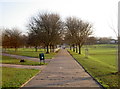
Redcatch Park
A peaceful afternoon in February. See Image] for the football pitch alongside the path.
Image: © Neil Owen
Taken: 1 Feb 2012
0.11 miles
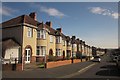
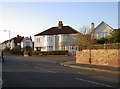
5
Friendship Road houses, Knowle, Bristol
Viewed from the Axbridge Road end looking towards Stoneleigh Road.
Image: © Jaggery
Taken: 11 Nov 2012
0.12 miles
6
Stoneleigh Road, Knowle, Bristol
Viewed from Broad Way looking along Stoneleigh Road towards Redcatch Road, about 350 metres ahead.
Image: © Jaggery
Taken: 11 Nov 2012
0.13 miles
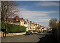
7
Junction of Redcatch Road and Woodbridge Road
Early evening sunshine bathes this suburban scene of Inter-war housing. See Image] for a benchmark that is almost obliterated.
Image: © Neil Owen
Taken: 1 Feb 2012
0.13 miles
8
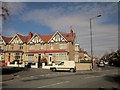
Houses on Tennis Road, Knowle
At the junction of the no through road with Redcatch Road (foreground) and Calcott Road (right), as well as Image
Image: © Derek Harper
Taken: 15 Mar 2014
0.14 miles
9
Calcott Road, Knowle
Image: © Derek Harper
Taken: 15 Mar 2014
0.14 miles
10
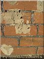
Buttered up
A benchmark in the wall of Redcatch Road, partly smothered by some new pointing. See http://www.bench-marks.org.uk/bm41480 for the entry in the Benchmark Database and Image] for a location view.
Image: © Neil Owen
Taken: 1 Feb 2012
0.14 miles