IMAGES TAKEN NEAR TO
Wells Road, BRISTOL, BS4 2PJ
Introduction
This page details the photographs taken nearby to Wells Road, BS4 2PJ by members of the Geograph project.
The Geograph project started in 2005 with the aim of publishing, organising and preserving representative images for every square kilometre of Great Britain, Ireland and the Isle of Man.

There are currently over 7.5m images from over14,400 individuals and you can help contribute to the project by visiting https://www.geograph.org.uk
Image Map
Images are licensed for reuse under creativecommons.org/licenses/by-sa/2.0
Notes
- Clicking on the map will re-center to the selected point.
- The higher the marker number, the further away the image location is from the centre of the postcode.
Image Listing (163 Images Found)
Images are licensed for reuse under creativecommons.org/licenses/by-sa/2.0
Image
Details
Distance
1
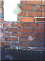
Benchmark on #253 Wells Road (Calcott Road)
Ordnance Survey cut mark benchmark described on the Bench Mark Database at http://www.bench-marks.org.uk/bm35343.
Image: © Roger Templeman
Taken: 28 Aug 2010
0.03 miles
2
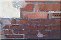
Ordnance Survey Cut Mark
This OS cut mark can be found on No253 Wells Road. It marks a point 76.633m above mean sea level.
Image: © Adrian Dust
Taken: 4 Nov 2021
0.03 miles
3
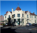
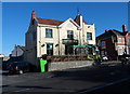
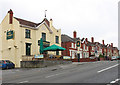
A view from the south of The George, Knowle, Bristol
Pub at 228 Wells Road on the corner of Somerset Road.
Image: © Jaggery
Taken: 11 Nov 2012
0.03 miles
4
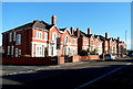
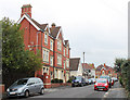
Wells Road houses, Knowle, Bristol
Houses on the north side of Wells Road between Somerset Road and Beaconsfield Road.
The George http://www.geograph.org.uk/photo/3224676 is out of shot on the left.
Image: © Jaggery
Taken: 11 Nov 2012
0.03 miles
5
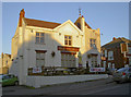
West side of The George, Knowle, Bristol
Pub at 228 Wells Road on the corner of Somerset Road.
Image: © Jaggery
Taken: 11 Nov 2012
0.04 miles
6
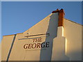
The George in gentler colours
The well-known old watering hole has had some new paint applied.
As the Totterdown area was being opened up in the mid-late nineteenth century, the George Inn was built on the main road in a little spot by itself. Opposite was Fairfield (Firfield?) House, a small mansion with glasshouses associated with it. However, as the suburb inexorably spread and encroached, the terracing swallowed the remaining land, and the house was demolished to make way for Belluton Road. The George used to have housing right up to its wall but that was destroyed in the Blitz.
Image: © Neil Owen
Taken: 20 Jan 2017
0.04 miles
7
George's warm welcome
Some painted encouragement on the side of the pub.
Image: © Neil Owen
Taken: 20 Jan 2017
0.04 miles
8
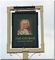
2010 : Sign outside The George, Wells Road, Bristol
As no regnal number is given this should be a portrait of George I but seems to show George II. It compares with the image shown here https://www.npg.org.uk/collections/search/portrait/mw02449/King-George-II
Image: © Maurice Pullin
Taken: 7 Nov 2010
0.04 miles
9
2010 : The George, Wells Road, Bristol
On the corner of Somerset Street.
Could find nothing of its history on the www except it is mid 19th century.
Image: © Maurice Pullin
Taken: 7 Nov 2010
0.04 miles
10
2010 : The Old Bill on Calcott Road, Knowle
An ex police station now taken over as a private house.
Looking toward Wells Road.
Image: © Maurice Pullin
Taken: 7 Nov 2010
0.05 miles