IMAGES TAKEN NEAR TO
Talbot Road, BRISTOL, BS4 2NU
Introduction
This page details the photographs taken nearby to Talbot Road, BS4 2NU by members of the Geograph project.
The Geograph project started in 2005 with the aim of publishing, organising and preserving representative images for every square kilometre of Great Britain, Ireland and the Isle of Man.

There are currently over 7.5m images from over14,400 individuals and you can help contribute to the project by visiting https://www.geograph.org.uk
Image Map
Images are licensed for reuse under creativecommons.org/licenses/by-sa/2.0
Notes
- Clicking on the map will re-center to the selected point.
- The higher the marker number, the further away the image location is from the centre of the postcode.
Image Listing (55 Images Found)
Images are licensed for reuse under creativecommons.org/licenses/by-sa/2.0
Image
Details
Distance
1
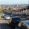
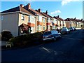
Talbot Road, Bristol
Looking east from a point roughly equidistant from the Buller Road and Lodway Road junctions.
Image: © Jaggery
Taken: 5 Nov 2012
0.02 miles
2
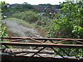
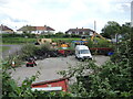
Old view from an old bridge
The land around Station Road is now a recycling and reclamation business. The Bristol and North Somerset railway line closed in 1973 and just beyond the diggers was the site of the old Brislington station.
Image: © Neil Owen
Taken: 1 May 2020
0.03 miles
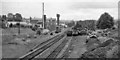
3
Brislington, West Moor Lane, 1963
View NE, towards A4 Bath Road: not quite where Brislington station had been - see Image It shows well the commerce of the day, fifty years ago.
Image: © Ben Brooksbank
Taken: 12 Aug 1963
0.03 miles
4
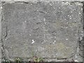
Ordnance Survey Cut Mark
This almost eroded OS cut mark can be found on north parapet of the railway bridge on Talbot Road. It marks a point 40.764m above mean sea level.
Image: © Adrian Dust
Taken: 22 Apr 2022
0.04 miles
5
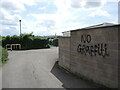
Wall irony
Someone has a certain sense of humour. At least they can spell properly.
Image: © Neil Owen
Taken: 19 May 2022
0.04 miles
6
Using the old station site
This used to be Brislington station, when the Bristol and North Somerset line was operating. It was a single platform on a single line, but was closed to passengers in 1959; it finally closed completely in 1963. Since then, it has become a metal recycling yard.
Image: © Neil Owen
Taken: 19 May 2022
0.06 miles
7
Brislington Station (remains)
View southward, towards Radstock; ex-GWR Bristol (Temple Meads - North Somerset Junction) - Radstock - Frome branch. The station had been closed to passengers when the local service was withdrawn on 2/11/59, goods ceased here 7/10/63 but the line lasted until 7/68.
Image: © Ben Brooksbank
Taken: 12 Aug 1963
0.07 miles
8
Lodway Road, Bristol
Viewed from the corner of Kensington Park Road looking towards Talbot Road.
Image: © Jaggery
Taken: 5 Nov 2012
0.13 miles
9
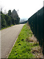
Cycle Path - NCN 3
This cycle path runs along side the Talbot Road allotments (behind the green fence).
Image: © Linda Bailey
Taken: 26 Mar 2007
0.14 miles
10
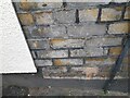
Ordnance Survey Cut Mark
This OS cut mark can be found on No48 Kensington Park Road. It marks a point 38.835m above mean sea level.
Image: © Adrian Dust
Taken: 22 Apr 2022
0.14 miles