1
Any questions?
A section of St Martin's Road is under the shovel. A bright orange unit is placed on top of it and helpfully asks if there are any questions. The panel it is on seems like a boarded window that might just open up and have someone emerge from inside. However, no-one asked so on-one appeared.
Image: © Neil Owen
Taken: 19 May 2022
0.01 miles
2
Priory Surgery, Knowle, Bristol
Doctors' surgery at 326 Wells Road, on the corner of Priory Road.
Image: © Jaggery
Taken: 11 Nov 2012
0.06 miles
3
Benchmark at the end of Priory Road
A cutmark, as listed in the Benchmark Database: https://www.bench-marks.org.uk/bm171225 , is at the junction of the road with Wells Road. See
Image] for a wide view.
Image: © Neil Owen
Taken: 19 May 2022
0.06 miles
4
Where Priory Road meets the Wells Road
The corner of the road shows some of the more upmarket homes that were built over a century ago as Knowle began to grow markedly. A benchmark can be found on the stone gate pier - see
Image
Image: © Neil Owen
Taken: 19 May 2022
0.06 miles
5
Wells Road, Knowle
Houses on the east side of the A37 between St Martin's Road and Priory Road.
Image: © Derek Harper
Taken: 10 Mar 2018
0.07 miles
6
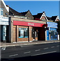
Britannia, Knowle, Bristol
Beneath the Britannia name on the branch at 316 Wells Road, Knowle, smaller text shows
"part of the Co-operative Bank".
Previously the Britannia Building Society, Britannia merged with Co-operative Bank in 2009.
Next door on the right is Broadwalk Tailoring & Alterations For Ladies & Gents.
Image: © Jaggery
Taken: 11 Nov 2012
0.07 miles
7
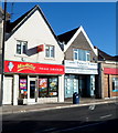
Miss Millie's Fried Chicken, Knowle, Bristol
The business at 312 Wells Road is one of 10 Miss Millie's Fried Chicken branches
in Bristol, Weston-super-Mare and Cardiff.
The business is named after Mildred, the daughter of Kentucky Fried Chicken's Colonel Sanders.
Next door is the office of Cooke Painter Limited, solicitors.
Image: © Jaggery
Taken: 11 Nov 2012
0.08 miles
8
Putting up a new sign
The pub at Broadwalk is over a century old, but like many others no longer pulls pints. It has had a few different owners in recent years and now is a Chinese restaurant. Or is it about to change into something else?
Image: © Neil Owen
Taken: 30 May 2019
0.08 miles
9
Broadwalk before the bulldozers arrive
Knowle's large shopping centre was built in the 1970s but it seems it has come to the end of the line. Plans to demolish it and rebuild a new centre - along with lots of new houses - are in hand.
Image: © Neil Owen
Taken: 19 May 2022
0.09 miles
10
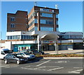
Broadwalk Shopping Centre, Knowle, Bristol
The shopping centre entrance is on the corner of Broad Walk and Wells Road.
On the right, above a Subway, is Knowle branch library, one of 27 in the Bristol City Council library service. Knowle library was previously located in Redcatch Road. http://www.geograph.org.uk/photo/3225277
Image: © Jaggery
Taken: 11 Nov 2012
0.09 miles


